Take a look at your bathroom sink. Besides the drain at the bottom, there should be a higher overflow hole. This is designed so you don’t leave the bathroom faucet on and flood your bathroom. America built Spillways for the same reason…. so we don’t flood what we want to protect.
The Great Mississippi Flood of 1927 was the most destructive river flood in the history of the United States, with 27,000 square miles (70,000 km 2) inundated up to a depth of 30 feet (9 m). Link Songs were written about the Great Flood, including a song from a couple in Kansas who recorded “When the Levee Breaks”, which was re-recorded by Led Zeppelin. The howling harmonica, despair of Robert Plant’s voice, and monotony of the drums, all speak to the devastation of a massive flood. Almost 50yrs after the song’s release, it’s still a perennial favorite in New Orleans and south Louisiana……… because we all …….. know.
Here is the original recording of the song from Kansas Joe McCoy and Memphis Minnie. The pics of the flood in the video are surreal.
After the flood, the Dept of Interior decided to build Spillways to try to control flood waters from excessive spring melts upstream. The Spillways worked much like the overflow hole on your bathroom sink. Massive gates would open, and relieve high water. The Bonnet Carre Spillway opens between the Mississippi River and Lake Pontchartrain, so the water can escape to the Gulf of Mexico.


If you look at the picture above, look behind the weatherman’s back, close to the lake. That white area is a subdivision of New Orleans. It’s Chateau Estates, built my school chum Leslie Occhipinti’s daddy. Where the weatherman’s knees are, and a little bit to the right off screen, is the New Orleans Int’l Airport. My own subdivision was further to the right along the lake. The Bonnet Carre Spillway protects both New Orleans and alleviates floodwaters for a third of the country. It’s MASSIVE.
It takes cranes to open ONE GATE of the spillway and the opening of a Spillway is such an event, people bring their kids to see it happen.
From the air, the cranes look like ants. We all pay homage to the Corps of Engineers guys who are brave enough to stand in the middle of all that water.
The Bonnet Carre Spillway is rarely used. The Morganza Spillway has not been used since 1973 and it is upriver. Morganza Spillway was opened on May 9, 2019 – second time in my lifetime. Link When one of the Spillways is opened, it can divert 1.5 million cubic feet of water per second. For comparison, it would fill up the Superdome in 50 seconds.
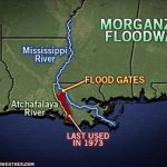
Opening the Morganza Spillway will flood the Bayous of the Atchafalaya Basin. It’s serious. I remember when it was opened in 1973. It was the year we moved to New Orleans. I was 10yrs old. Our Louisiana history class toured the spillways, both Morganza and the Bonnet Carre. At 10 yrs old, as a little girl from the suburbs of Chicago, I read stories about the waterworks required for Hanging Gardens of Babylon, or the Roman Aqueducts…. and Dad was part of the team for massive projects like the St. Louis Arch, John Hancock Bldg, Sear’s Tower (I was there when Dad helped lay the cornerstone). I grew up around big building projects. Heck, our family was transferred to New Orleans for his work on One Shell Square and the Superdome…. but the Spillways are massive….. like something out of a movie….. an alien world…… like looking at Hoover Dam and standing on the ground in front of it.
The size of it is mind-boggling.
I had never seen anything like it.
As I grew up, local high schools and fraternities would hold large gatherings, field days, outdoor concerts, in the expansive acreage on the dry side of the Spillways. We used to take horses there and picnic all the time. You could touch the massive gates and the backdrop was foreboding. The Corp claims 400K visitors a year. Link The space is perfect for a large gathering and stretches for a few miles miles between the Mississippi River levees and the shores of Lake Pontchartrain.

Yeah, the Great Flood of 1927 is probably the reason there are still 2500 engineers located at the Corps of Engineers facility in Vicksburg. Today, we refer to it as Construction “Wonderland”. Gunner’s girlfriend is a geo-engineer working on her masters, and interning there this summer.
Growing up in the area, we always knew, when it came time to open a Spillway, it was an emergency, and the country was in trouble. There was a sense of urgency across all classes and races – we’re all subject to the wrath of Mother Nature and HER river. Besides local press announcing the opening of the Bonnet Carre Spillway, I could hear the horns, from miles away at our house. It’s the kind of sound which creeps down your spine — like the first time you hear a tornado siren… and it goes on for what seems like hours.
My extended family lived around the Quad Cities, both sides of the Mississippi in Illinois and Iowa. Therefore, I could empathize easily. Today, in this forum, we hear from Dep and Nebraska Filly and we feel their pain. Guys like our own Rayzorbak are on the front line, with the Corps of Engineers. God Bless’em. Our country is in trouble and it’s time to help. Open the gates.
It’s worthwhile to note, before the Spillways were built, seasons of large floods would deposit millions of tons of silt into the Atchafalaya basin, creating new land. After the Spillways were built, controlling the river, we had “enormous problems” with the Gulf Of Mexico and sea water encroaching and eroding the land of the Atchafalaya. Saltwater tides are relentless. Think of the area as millions of acres which act like a filter, a permeable barrier between freshwater and saltwater, which teams with wildlife. Losing land was a big problem….. about 10 square miles a year.


As a schoolkid, we would join scientists in the summer who were analyzing the erosion (read as playing with the alligators/pelicans/turtles) which was ALLEGEDLY “caused” by the Corps of Engineers controlling the river instead of allowing a river delta to develop naturally. Today, those same scientists, now funded by “green groups” are complaining about opening the Spillways because the sudden infusion of freshwater destroys oyster beds, kills dolphins and loggerhead turtles. Yes, great local publicity for the three dolphins who have washed ashore during this emergency. Now, they want the Spillways closed. These are the people who are focused on the problem in their own backyard, instead of a MUCH larger problem for the entire country.
Can’t please a climate activist or a politician.
The politicians and the climate scientists were VERY upset about it…… but they never talked about the alternative……… like the Great Flood of 1927. No context. No historical perspective.
They forget the history of the land, the people, and disrespect local lore. Stories from SEVEN states of death and destruction. THEY think we’re stupid….. but we remember the stories of our grandparents.

See this picture above? The building with the Coca-Cola sign painted on the side? I’ve been in that building. The Bidenharn Family of Vicksburg were the first to bottle Coca-Cola. The building sits high, in the midst of a thriving downtown. No one could ever imagine it flooding…… but it did.
The Spillways were built for emergencies. We’re the choke point for a third of the country. We understand our responsibility. Let the water flow.

End…


Fantastic writing and explanation! (I say this as someone WAY upstream from all of this, living less than a mile from the divide between the Platte and Arkansas rivers; both major tributaries of the Mississippi/Missouri.)
Fascinating, Daughn, and so educational. This deserves a wide audience, not only because so many are currently affected, but to understand the much bigger picture of how much of our country depends on nature’s valves and what we’ve done to help or interfere, as the case may be.
I’m with Steve … way upstream… although Colorado’s Front Range “500-year Flood” a few years ago gave me heightened respect for the power of water, and our vulnerability to its capriciousness.
Our canyon streams are unseasonably low despite a very rainy, snowy May. Colder temperatures have kept our peaks snowcapped, and the melt is starting very late. Still I am perplexed as to why the mid-altitude reservoirs haven’t yet been released to make way for the inevitable flow from higher peaks. It’s a little unnerving.
Thanks again for an invaluable lesson.
And from the part of the basin(s) that all come together 500 miles upstream, we feel your pain, although a little differently. We’re on our second 500 year flood in less than 30 years. The previous flood of that magnitude was 1844. All that water is headed your way, spillways or not. Red tide or not. Oysters, dolphins, and the turtles…sorry, but this is Mother Nature doing the damage at this point.
The first crest at the Arch is predicted at 46 feet, 16 above flood which is 30 feet above what is considered zero when there’s still 16 feet in the navigation channel. That’s 62 feet of water. The measurement of just how high the Mighty Mississippi is will be taken tomorrow morning. The record from August 1, 1993 is 49.8 feet, and if there was not a levee break downstream two hours later, the river would have gone over the flood wall.
A few notes from up here this go around:
Grafton, Hardin and Alton, Illinois, all north of the Missouri confluence, are all under water, as per usual.
Bridges are closed to the tune of six of the ten over the Missouri River in the state are closed. And unless I miss my guess, three of the open ones connect St. Louis County with St. Charles. (They’re all relatively new.) The only one over the Mississippi that is problematic is the Jefferson Barracks (south county) and that has nothing to do with the flood. It’s open, but emergency repairs are still underway.
Barge traffic is at a standstill. The barges, let alone the tows, cannot fit under the trusses of almost any bridge.
Daily we are hearing of levee breaks. High water for weeks on end will compromise the base.
Sandbagging the usual spots is going on. Anyone who feels they could use a high impact workout, head this way.
We’re expecting more rain in the basin in the next week, so this is far from being over.
Seriously, if the Blues weren’t in the Stanley Cup Finals, things around here would be downright morose.
Opening the spillways downstream is necessary for its own reasons (that Daughn has explained well), but opening those spillways won’t help you out right now. Daughn’s spillways basically give the Mississippi additional routes to the ocean, but as far upstream as St. Louis is, there’s only ONE route to the ocean from there, and it’s the one that’s currently overflowing.
I realize that. However, all this water is headed her way.
…As well as what landed in the Arkansas.
Yeah, those spillways will have to open in a couple of weeks.
Bonnet Carre has been open for about 6 weeks.
Thus, all the complaints about the 3 dead dolphins. Other one opened on May 9th.
We’re supposed to crest at 23′ above flood stage. Forecasting about 586,000 acres flooded. We have double levees from Memphis to Helena, widening the river by 2 additional miles.
It’s an extraordinary sight.
Humbling.
Yes, it is. The power of nature is something to behold sometimes.
It really is impossible to describe.
Raw power.
timely post, daughn…and very interesting…esp in light of Inv 91L churning its way north out of The Bay of Campeche in The GoM…and what kind of an impact it will have there as it’s predicted to head into Texas and Louisiana…and could develop into the 2d named storm of this 2019 season…as Barry (heh heh)..
an article relevant to this very topic…
Morganza Spillway Opening Delayed But Tropical System Might Also Threaten New Orleans
https://www.nola.com/weather/2019/06/morganza-spillway-opening-delayed-but-tropical-system-may-also-threaten-new-orleans.html
June 3, 2019
They need to get that water out of the way, as much as possible, as fast as possible.
A hurricane or tropical depression will only push the water back “up” the river and create an enormous disaster.
Excellent post, Daughn.
😃👍
My husband and I were talking about this, this morning.
Since we get such long dry spells without a drop of rain…we hate to complain when we are getting too much.
So we don’t.
But all the flooding that we’ve had up here is now making it’s way down to the Mississippi River.
So we know what that means…for all the folks downriver.
The climate activists are just going to have to get over themselves and let the grownups do what is necessary.
Yes…Open The Spillways!
And here I was complaining that the Red River here in Texas keeps moving south and making us smaller and Oklahoma larger.
The state line is the middle of the river and it keeps adding to OK. 😣
Thank you, Daughn for giving me perspective.
Oh hey, the argument about the Red River is valid!
So?!!! LOL! WE like it that way! LOL!!!!!!!!!!!!!!
I know! It’s too dang funny!
Speaking as a Longhorn….
HOOK ‘EM HORNS!!
😎
Shhh, I love our OK neighbors. LOL. Still, that was funny as heck.
I used to have a bumper sticker on my truck that said: “If I owned Oklahoma and Hell, I’d live in Hell and rent out Oklahoma.”
Moon a Sooner!!! Man, I miss our rivalry with them from the good old days!
Best football game EVER, Orange Bowl in 1984.
I do have to say, THIS was a really good one from 2008. I was watching in our oh-so-liberal neighborhood in Manassas and screaming “kick a field goal, kick a field goal.” No doubt the neighbors considered calling in a disturbance in the area!
Reblogged this on RedLegLeader Blog and commented:
The Spillways were built for emergencies. We’re the choke point for a third of the country. We understand our responsibility. Let the water flow.
Yes …
Well said. Thanks for this.
We would all be better people if we spent just a little more time thinking about the stories our grandparents used to tell.
We learned. Our kids don’t learn.
Our grandparents undertook MASSIVE construction projects. The infrastructure was unlike anything else in the world. They did it, then, they fought a war and went to the moon.
We need something BIG.
…..and we’ve got a bunch of medieval chicana lesbian studies graduate baristas with $150K of college debt…..
Just dropping by to read the new posts…
OPEN THE FLOOD GATES!!!
“They’re tryin to wash us away!”
Neuman couldn’t resist his lefty shot at President Coolidge.
I like the song…it captures something of the feeling of helplessness of being in a flood.
“President Coolidge came down in a railroad train
With a little fat man with a note-pad in his hand
The President say, “Little fat man isn’t it a shame what the river has done
To this poor crackers land.“
Ya wonder what he thought Coolidge was going to do in 1927…
Thanks to Daughn for documenting what’s happening down river.
Thanks Coldeadhands, reminds me why I love Louisiana.
Cryin’ won’t help ya
Prayin’ won’t do ya no good
Nooo
Cryin’ won’t help ya
Prayin’ won’t do ya no good
When the levee breaks
Mama you got to move
Wooo hooo
.
From Wikipedia….
Music critic Robert Christgau cited Led Zeppelin’s version of “When the Levee Breaks” as their fourth album’s greatest achievement. He argued that, because it plays like an authentic blues song and “has the grandeur of a symphonic crescendo”, their version both transcends and dignifies “the quasi-parodic overstatement and oddly cerebral mood of” their past blues songs. Mick Wall called it a “hypnotic, blues rock mantra.” AllMusic critic Stephen Thomas Erlewine commented that the song was the only piece on their fourth album on par with “Stairway to Heaven” and called it “an apocalyptic slice of urban blues … as forceful and frightening as Zeppelin ever got, and its seismic rhythms and layered dynamics illustrate why none of their imitators could ever equal them.” In The Rolling Stone Album Guide (2004), Greg Kot wrote that the song showed the band’s “hard-rock blues” at their most “momentous”.
The band recorded an early version of the song in December 1970 at Headley Grange, using the Rolling Stones Mobile Studio. It was later released as “If It Keeps On Raining” on the 2015 reissue of Coda. Prior to relocating to Headley Grange, they tried unsuccessfully to record it at Island Studios at the beginning of the recording sessions for their fourth album.
Page and John Paul Jones based their guitar and bass lines on the original song. However, they did not follow its twelve-bar blues I–IV–V–I structure, but instead used a one-chord or modal approach to give it a droning sound. Plant used many of the lyrics, but took a different melodic approach. He also added a harmonica part; during mixing, a backward echo effect was created, whereby the echo is heard ahead of the source.
John Bonham’s drumming, played on a Ludwig kit, was recorded in the lobby of Headley Grange using two Beyerdynamic M160 microphones which were hung up a flight of stairs; output from these were passed to a pair of Helios F760 compressor/limiters. A Binson Echorec, a delay effects unit, was also used.
Portions of the song were recorded at a different tempo, then slowed down, explaining the “sludgy” sound, particularly on the harmonica and guitar solos. It was the only song on the album that was mixed at Sunset Sound in Hollywood, California (the rest being remixed in London). Page identifies the panning on the song’s ending as one of his favourite mixes “when everything starts moving around except for the voice, which remains stationary.” The song was difficult to recreate live; the band only played it a few times in the early stages of their 1975 U.S. Tour.
.
FG&C rating ⭐️⭐️⭐️⭐️⭐️
Best heard with high quality headphones, volume 6/10….although you will want to press the headphones in at certain points, particularly the beginning harmonica
The song is haunting.
I remember the first time I put earphones on husband and said, “……. just listen to this…..”, and the expression on his face.
Memphis Minnie, who wrote the original lyrics, was living in Walls, Mississippi, when the levee broke.
It’s about 20 minutes from me.
Couple of years ago, husband’s college roommate from Holy Cross came down for a visit.
He’s a history teacher, voted Best Teacher in Massachusetts several years ago, and he was on his great southern Civil War Tour. He’s an earthy crunchy type, drives a Prius, but we got along famously. He has all KINDS of preconceived notions about me. Poor lil’ lamb.
Anyway.
Husband and his college roommate buzzed around here for days looking at old monuments. THEN, they took off for Vicksburg for about a week.
Now, I was from the north, so I understand when northerners are shocked and surprised when they come to the south and begin to ask questions about the Civil War.
We didn’t learn much about the Civil War in northern schools.
In the south, we spent years on it.
Here, it’s like it happened yesterday, because it was in our backyard. Same dichotomy with the flood of ’27.
The Great 1927 Flood is an open wound – still, in the town of Vicksburg.
There’s even a museum for it, which the boys visited.
Add to that, there really are 2500 engineers and scientists, plus their families and friends, who work for the Corps of Engineers, based in Vicksburg. So, it’s kind of like living in Cape Canaveral in the 1970’s and trying to ignore NASA. The Corps primary responsibility is management of the Mississippi River Levee System (along with an ARMY testing facility which is like DARPA with bigger toys).
The funny thing, the teacher had no understanding of the music of the Delta, and how important it was to the culture. Good Catholic boy that he was, he had no rhythm. He had never heard the blues, knew nothing about the Crossroads. So, along with ham sandwiches and fried chicken, I loaded up the Prius with Muddy Waters, John Lee Hooker, …….. and all their buddies……. all the way up to Tina Turner, The Stones, Stevie Ray Vaughan, Thoroughgood and Zeppelin.
Do you have the visual yet? Two Irish white boys from Massachusetts, with the blues blaring out of the speakers of a PRIUS…….. yeah.
Funny thing happened along the way. I swear, that teacher came home a week later with a beard, a changed man. He had swagger. Once the blues gets into your soul……….
My thoughts are with all those in the paths of the flood.
dw247
I was reading about the spillways… Hubby and I were visiting NO May of 2011, the start of a six week car trip.. The Morganza spillway was opened then to alleviate the flooding in the lake. I still remember driving west on I10 and the swamp was filling up behind us… Of course, my memory is bad.. so I looked this up.. We were at an old but distinguished hotel and met a film maker… He and my husband discussed the flooding and it got a little out of hand….. I wish I could remember,, but he made films about the Cajun culture… hmmmmmm anyway…
https://earthobservatory.nasa.gov/images/50623/morganza-spillway-opens-in-louisiana