
What is it that feeds our battle, yet starves our victory?
First Things First
Today sees two memorial services for “Sam”: Susan P Sampson (Deplorable Patriot) at 10 AM CST (at St. Roch Roman Catholic Church in St. Louis) and Sam, PAVACA’s brother at 2PM EST (Peeples Valley Baptist Church in Cartersville, Georgia).
RIP
We carry on the fight, in memory of the fallen.
Do We Still Need the Kang (Mis)Quote?
I’m still using the quote about winning the battles but losing the war. It seems like this doesn’t make sense right now given that we seem to be going from triumph to triumph.
On the contrary. This is the exception that proves the rule. The quote isn’t just a lament, it’s to point out why we can never seem to win.
You see, the RINOs cannot interfere and that is why, just for once, we are actually winning. And that is just one more piece of evidence (for the willfully blind) as to what I have been saying with that quote.
It stays.
Speaker Johnson
Pinging you on January 6 Tapes
Just a friendly reminder Speaker Johnson. You’re doing some good things–or at least trying in the case of the budget–but this is the most important thing out there still hanging. One initial block released with the promise of more…and?
We have American patriots being held without bail and without trial, and the tapes almost certainly contain exculpatory evidence. (And if they don’t, and we’re all just yelling in an echo chamber over here, we need to know that too. And there’s only one way to know.)
Either we have a weaponized, corrupt government or we have a lot of internet charlatans. Let’s expose whatever it is. (I’m betting it’s the corrupt weaponized government, but if I am wrong, I’d like to see proof.)
Justice Must Be Done.
The 2020 election must be acknowledged as fraudulent, and steps must be taken to prosecute the fraudsters and restore integrity to the system.
Yes this is still true in spite of 2024. Fraud must be rooted out of our system and that hasn’t changed just because the fraud wasn’t enough to stop Trump winning a second term. Fraud WILL be ramped up as soon as we stop paying attention.
Otherwise, everything ends again in 2028. Or perhaps earlier if Trump is saddled with a Left/RINO congress in 2026, via fraud.
Small Government?
Many times conservatives (real and fake) speak of “small government” being the goal.
This sounds good, and mostly is good, but it misses the essential point. The important thing here isn’t the size, but rather the purpose, of government. We could have a cheap, small tyranny. After all our government spends most of its revenue on payments to individuals and foreign aid, neither of which is part of the tyrannical apparatus trying to keep us locked down and censored. What parts of the government would be necessary for a tyranny? It’d be a lot smaller than what we have now. We could shrink the government and nevertheless find it more tyrannical than it is today.
No, what we want is a limited government, limited not in size, but rather in scope. Limited, that is, in what it’s allowed to do. Under current circumstances, such a government would also be much smaller, but that’s a side effect. If we were in a World War II sort of war, an existential fight against nasty dictatorships on the brink of world conquest, that would be very expensive and would require a gargantuan government, but that would be what the government should be doing. That would be a large, but still limited government, since it’d be working to protect our rights.
World War II would have been the wrong time to squawk about “small government,” but it wasn’t (and never is) a bad time to demand limited government. Today would be a better time to ask for a small government–at least the job it should be doing is small today–but it misses the essential point; we want government to not do certain things. Many of those things we don’t want it doing are expensive but many of them are quite eminently doable by a smaller government than the one we have today. Small, but still exceeding proper limits.
So be careful what you ask for. You might get it and find you asked for the wrong thing.
Political Science In Summation
It’s really just a matter of people who can’t be happy unless they control others…versus those who want to be left alone. The oldest conflict within mankind. Government is necessary, but government attracts the assholes (a highly technical term for the control freaks).
His Truth?
Again we saw an instance of “It might be true for Billy, but it’s not true for Bob” logic this week.
I hear this often, and it’s usually harmless. As when it’s describing differing circumstances, not different facts. “Housing is unaffordable” can be true for one person, but not for another who makes ten times as much.
But sometimes the speaker means it literally. Something like 2+2=4 is asserted to be true for Billy but not for Bob. (And when it’s literal, it’s usually Bob saying it.) And in that sense, it’s nonsense, dangerous nonsense. There is ONE reality, and it exists independent of our desires and our perceptions. It would go on existing if we weren’t here. We exist in it. It does not exist in our heads. It’s not a personal construct, and it isn’t a social construct. If there were no society, reality would continue to be what it is, it wouldn’t vanish…which it would have to do, if it were a social construct.
Now what can change from person to person is the perception of reality. We see that all the time. And people will, of course, act on those perceptions. They will vote for Trump (or try to) if their perception is close to mine, and vote against Trump (and certainly succeed at doing so) if their perception is distant from mine (and therefore, if I do say so, wrong). I have heard people say “perception is reality” and usually, that’s what they’re trying to say–your perception of reality is, as far as you know, an accurate representation of reality, or you’d change it.
But I really wish they’d say it differently. And sometimes, to get back to Billy and Bob, the person who says they have different truths is really saying they have different perceptions of reality–different worldviews. I can’t argue with the latter. But I sure wish they’d say it better. That way I’d know that someone who blabbers about two different truths is delusional and not worth my time, at least not until he passes kindergarten-level metaphysics on his umpteenth attempt.
Lawyer Appeasement Section
OK now for the fine print.
This is the WQTH Daily Thread. You know the drill. There’s no Poltical correctness, but civility is a requirement. There are Important Guidelines, here, with an addendum on 20191110.
We have a new board – called The U Tree – where people can take each other to the woodshed without fear of censorship or moderation.
And remember Wheatie’s Rules:
1. No food fights
2. No running with scissors.
3. If you bring snacks, bring enough for everyone.
4. Zeroth rule of gun safety: Don’t let the government get your guns.
5. Rule one of gun safety: The gun is always loaded.
5a. If you actually want the gun to be loaded, like because you’re checking out a bump in the night, then it’s empty.
6. Rule two of gun safety: Never point the gun at anything you’re not willing to destroy.
7. Rule three: Keep your finger off the trigger until ready to fire.
8. Rule the fourth: Be sure of your target and what is behind it.
(Hmm a few extras seem to have crept in.)
(Paper) Spot Prices
Kitco “Ask” prices. Last week:
Gold $2,801.20
Silver $31.27
Platinum $989.00
Palladium $1,036.00
Rhodium $5,000.00
FRNSI* 134.508+
Gold:Silver 89.581+
This week, 3PM Mountain Time, markets have closed for the weekend. (This time, apparently, markets closed at 12:45, not 3PM.)
Gold $2,861.10
Silver $31.89
Platinum $984.00
Palladium $990.00
Rhodium $5,025.00
FRNSI* 137.406-
Gold:Silver 89.718-
Gold got into the 2870s range Wednesday, dropped then recovered some on Friday. Silver, of course succeeds in going down even on days when gold went up–down 40+cents on, Friday: a day when gold went up.
*The SteveInCO Federal Reserve Note Suckage Index (FRNSI) is a measure of how much the dollar has inflated. It’s the ratio of the current price of gold, to the number of dollars an ounce of fine gold made up when the dollar was defined as 25.8 grains of 0.900 gold. That worked out to an ounce being $20.67+71/387 of a cent. (Note gold wasn’t worth this much back then, thus much gold was $20.67 71/387ths. It’s a subtle distinction. One ounce of gold wasn’t worth $20.67 back then, it was $20.67.) Once this ratio is computed, 1 is subtracted from it so that the number is zero when the dollar is at its proper value, indicating zero suckage.
A Bit More Geology
I’ve talked about stratigraphy quite a lot in this series so far, and plan to move on to very different aspects of geology for a while…but I’m going to start by a review or summing up or practical application.
Here’s a diagram Valerie brought to the comments last week, as referenced by a YEC site which then went on to disparage it.
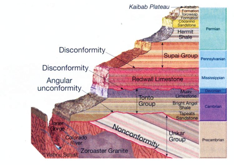
This is a cross section of the Grand Canyon, which is everybody’s favorite illustration of stratigraphy in action.
On the right are the attributions to different systems (periods) including the “Precambrian” which isn’t really a period (it’s the bucket they put the first three entire eons into sometimes). If you remember the names from last time (and I would be surprised if you did), there’s some missing names here.
Digression on how I remember them:
- I’ve heard names like Cambrian, Ordovician, Silurian, etc., enough to recognize them; but I could never remember the order they appear. I could remember Cambrian being the first Paleozoic period and the Permian being the last one, but Ordovician, Silurian, Devonian, Carboniferous (here divvied up into Mississippian and Pennsylvanian, as is often done in America), I could never remember. Until I looked at the initials: COS is of course the Colorado Springs airport code and living near there that’s easy for me to remember: Cambrian, Ordovician, Silurian. I could force myself to remember the Carboniferous is right before the Permian, which leaves (by elimination) the Devonian as the fourth period right after the Silurian.
- I have no difficulty with the Mesozoic because I grew up with a dinosaur nut as a kid; I got exposed to this a lot. Triassic (lame), Jurassic (cool dinosuars), Creataceous (really cool dinosaurs).
- The Cenozoic is both easier and harder. Easier because Paleogene obviously comes before Neogene (Paleo = old, Neo = new), so you can list off Paleogene and Neogene (and then just remember Quaternary–note not Quarternary), but harder because this one usually gets subdivided all the way down to epochs, one level further, even in children’s books! I didn’t talk about that at all last time except mentioning that in passing, but those all have names ending in -cene and I can’t ever remember them. (I’ll write them out here just for grins: Paleocene, Eocene and Oligocene (subdivisions of the Paleogene) and Miocene and Pliocene in the Neogene. The Quaternary gets broken down into the Pleistocene and Holocene–the Holocene is everything since the last ice age. Seven of these epochs and they rhyme and I can’t remember their ordering for nuthin.
Anyhow returning to the diagram, the entire Ordovician and Silurian, plus who knows how much late Cambrian and early Devonian, is completely missing from the sequence shown. And nothing after the Permian. In fact for all we know from looking at the diagram the last part of the Permian is missing too. What gives?
I’ve talked a lot about rock layers being laid down, and you might have got the impression this happens all the time everywhere, but that’s not true. In many cases nothing gets laid down for millions of years (imagine, for instance, a desert, or mountains, or the land under an icecap or glacier). And in many cases, something already laid down gets removed by erosion. Here what we see is a nice thick Cambrian layer followed immediately by a thin Devonian layer.
For all we know, there may have once been more Cambrian rock here, then some amount of Ordovician rock, then some Silurian rock…and then deposition stopped, and a bunch of stuff got eroded away until resuming near the end of the Devonian.
Or maybe none of that ever got laid down; deposition stopped right where we see it, then resumed late in the Devonian. We can’t tell–not from this diagram at least–we just know those layers aren’t there now.
(If you dig deeper you can learn a bit more. The Muav Limestone is the top Cambrian layer shown, and you can look that up in Wikipedia (and then chase down the sources if you really want to be thorough). In addition to describing the limestone as fine-grained and gray, it goes on to describe the extent of the formation. It turns out the Muav Limestone was laid down in the mid-to-late Cambrian, not at the very end (dates are given), and extends into Utah, Nevada and California…and it is of different thicknesses in different areas. In most places what lies on top of it is Mississippian rock, but in some areas (like the Grand Canyon) where it’s a bit thinner there’s Devonian rock there. Now you can reconstruct a bit what happened: The Muav was laid down. Then parts of it were eroded and there was a Devonian deposit, which probably got planed off by erosion but it lived on in places where the Muav was lower and it filled in deeper areas.
[When I think about the sheer amount of field work it takes to map these things, I am staggered. Geologists basically have to go everywhere to do this to this level of detail.]
The dividing line is labeled as a “disconformity.” It turns out that a disconformity is a specific type of unconformity. And an unconformity is any sort of gap in the stratigraphic sequence, which indicates a gap in deposition of sediment.
I can’t say it better than Wikipoo does so I’ll just quote it: “The rocks above an unconformity are younger than the rocks beneath (unless the sequence has been overturned). An unconformity represents time during which no sediments were preserved in a region or were subsequently eroded before the next deposition. The local record for that time interval is missing and geologists must use other clues to discover that part of the geologic history of that area. The interval of geologic time not represented is called a hiatus. It is a kind of relative dating.”
It’s called a “disconformity” when the unconformity is between parallel layers of sedimentary rock…as is the case here.
It is called a “nonconformity” when the upper layer is sedimentary and what is below is igneous or metamorphic rock, presumably partially eroded away before the sediments were deposited.
Also showing up in that diagram is an “angular unconformity” where the rocks below the unconformity are angled. There are parallel layers there but the layers are at a steep tilt. This usually happens because after the layers were deposited there was a mountain building episode that tilted the landscape. Then part was eroded away and the overlying sediment was deposited.
And of course at the very top, nothing above the Kaibab limestone, which (I went and looked) is early-to-mid Permian, so the late Permian either was never deposited here, or was and has been eroded away. But one shouldn’t judge such things from one location. Before we start looking elsewhere though, I’m going to paste in a different diagram of the Grand Canyon layers, one from the National Park Service:
Some occasional bluffs appear on top of the Kaibab that are of the “Moenkopi” formation.
But let’s look further afield, and if we do so we’ll be rewarded. Because the Kaibab is under many additional layers in Zion National Park. That nails it down; the Kaibab was once under a lot more rock than it is today. Here are the layers that appear above it in Zion:
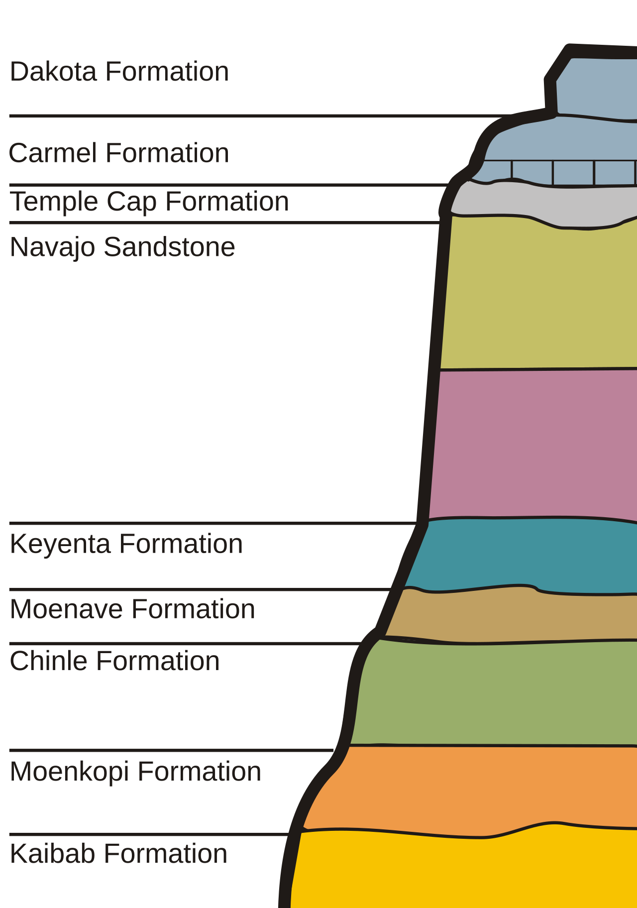
The Dakota formation spreads all over the Intermountain Western United States and further, it is seen in Kansas as well as the Dakotas. (And I can guess what I am going to find when I go look: YUP, it’s Cretaceous; the last period/system of the Mesozoic. (And the Dakota formation is mid-Cretaceous at that, not late Cretaceous). That’s because there was an “inland sea” called the Western Interior Seaway in the Western United States until then, and I’ve known about that since childhood. Yes, a shallow arm of the ocean where there are now highlands and even mountains.)
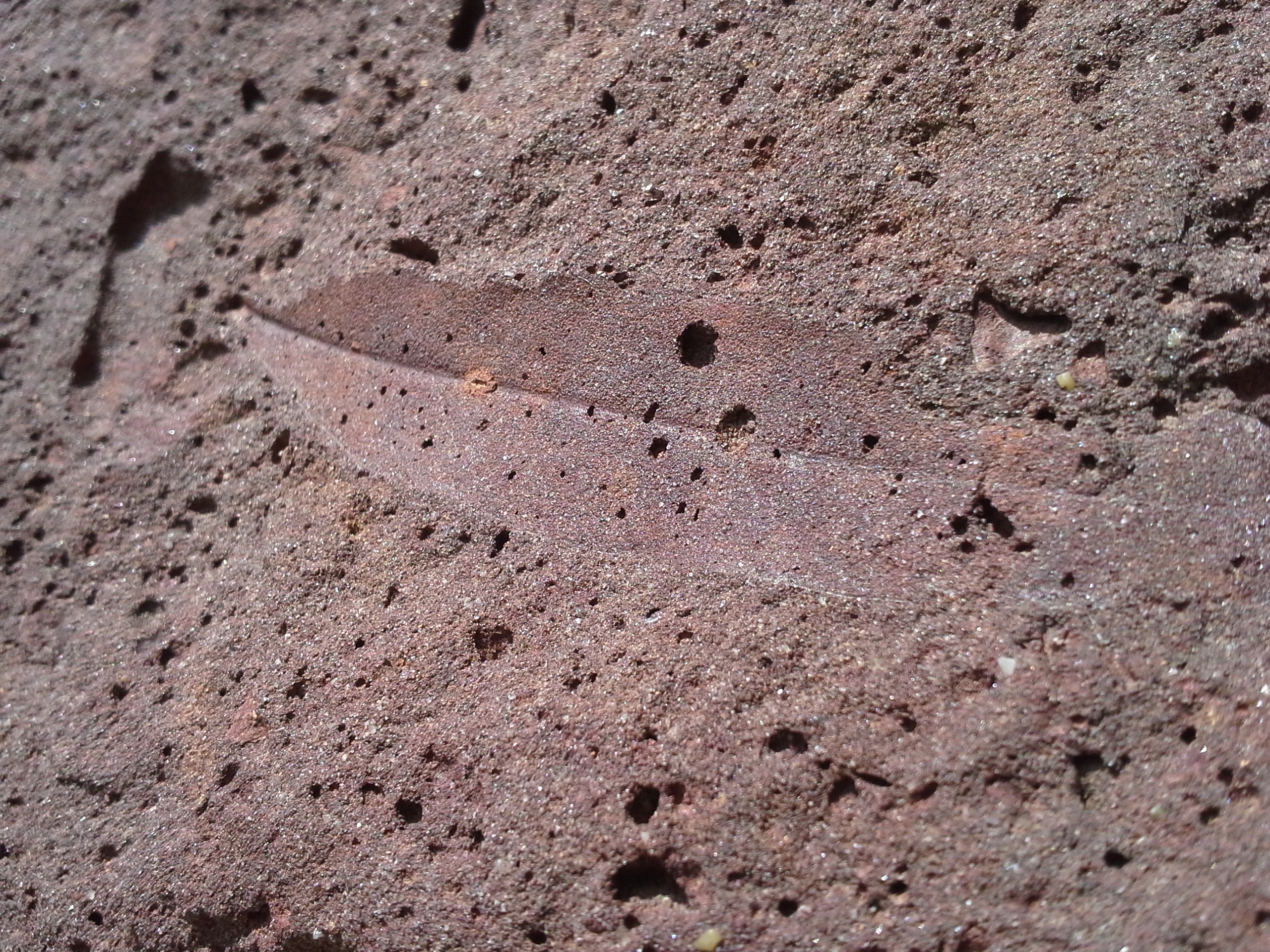
From Ellis County, Kansas (which is Western Kansas on or near I-70) we have this imprint fossil of a leaf; the rock contains significant iron. Apparently when this leaf got buried, the area was boggy sand near deciduous (leafy) trees. Other nearby areas have fossilized mollusc shells so there was also a beach near here at one point in time.
(You may have noticed a lot of those Zion Park formation names are quite redolent of the Southwest: Kaibab, Moenkopi, Chinle, Moenave, Keyenta, and Navajo. All were discovered on the Colorado Plateau, largely by watching the rock layers fly by as Wile E. Coyote fell thousands of feet whilst trying to get away from the anvil that was his traveling companion. Really, really, he should never have looked down.)
So what forces erode rocks? Or (by the way) the soil before it becomes a rock?
Many different things. But number one is:
Erosion by Water
And there are many ways for water to do this. Rainfall and surface runoff are what I (sometimes) see where I live, far away from the World Sump known as the ocean, so I’ll cover that one first.
The mere act of a raindrop hitting the ground can sometimes eject particles of soil. But much more dramatic erosion results from runoff; it can go downslope as sheet erosion, form rills, or even create gullies. Rills and gullies are qualitatively the same, but a rill is small enough that you can (if you are farming the land) fill it in just through normal tilling the soil.
Continuous water flow occurs in rivers and streams. Given time they can wear down rocks; rocks in the bed of a stream eventually become smoothed down into pebbles. Streams can not be fed by rainfall but also snow melt and springs.
Entire mountain ranges can, and will, be removed by these processes though it takes millions of years. Streams will first cut narrow, v-shaped canyons; as time progresses and the mountains erode away the channels will get more of a U profile, and eventually the stream ends up moving slowly through a broad river valley. Or one can often see such a progression following a stream downhill today. (Geologists even talk of “young” streams (the ones cutting narrow valleys) versus “mature” streams, with more rounded beds, and then finally “old age”, which are more like:
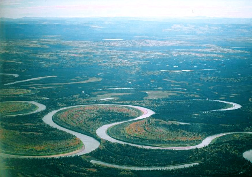
A stream in a wide flood plain, moving slowly, will eventually start to meander (look at a map of the lower Mississippi to see this in action today). The stream can cut across the meanders especially during a flood, and leave behind oxbow lakes as seen in this picture of the Nowitna River in Alaska.
Water flowing in a stream will pick up more “stuff” the faster it is flowing; when it’s a flash flood it can remove boulders. Slower moving streams will pick sand up off their beds and move it downstream. Fine Silt can stay suspended even along slow-moving nearly-flat rivers.
Of course it’s easiest for streams to pick up loose material like sand than to actually grind down rock, but the latter does happen…assisted some by the loose stuff the stream is carrying. (It is a mistake to compare a gully cut through soil to a canyon cut through rock and assume they are both being cut at the same rate.)
Where does it all go? Downstream of course, and the sediment carried off can be deposited a couple of different ways.
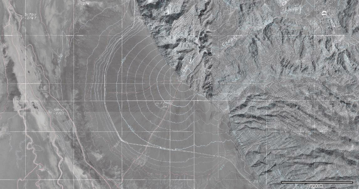
One is the “alluvial fan” where water can emerge from a narrow canyon into a larger valley. The water will spread out and slow down; These are plainly visible in the Basin and Range province of Nevada and California; here is an overhead picture of one in Death Valley:
And from ground level, also in Death Valley (but I don’t know if it’s the same one):
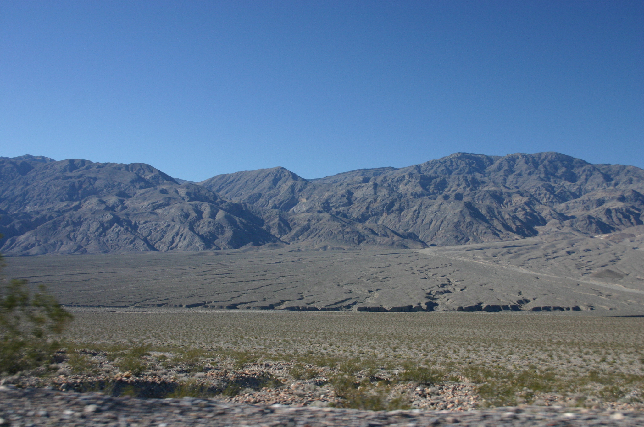
Alluvial fans can be many square kilometers in size and tend to have gentle slopes up to where the stream emerges from its canyon (and nothing says the stream has to run full time; it certainly doesn’t do so here). The deposited stuff tends to be coarser nearer the source, which makes sense: as the water exiting the canyon fans out, it slows down, as it slows down the bigger stuff will be deposited first, closest to where the water exited the canyon.
Alluvial fans have even been seen on Mars, an indication that water used to flow there. They also appear on Titan, but this isn’t due to water flow but rather liquid methane and ethane. As you might expect given the examples I’ve shown, these tend to show up in mountainous, arid places, though by no means must the place be as arid as Death Valley. Buried alluvial fans underlie Denver, Salt Lake City and Los Angeles and often contain groundwater. They also underlie the Ganges valley in India, being fed from the Himalayas. And of course ancient fans often end up becoming sedimentary rock and end up in the geologic column.
River deltas are another obvious destination. The Mississippi delta deposit is tens of thousands of feet thick; it’s so heavy it pushes the bedrock down into the Earth. But in less extreme cases, smaller streams dump sediment into ponds, swamps and oceans…and these could eventually end up becoming rocks in the geologic column.
Below is the mouth of the Amazon river, in Brazil. This river is titanic; it may not be the longest in the world (the other possibility being the Nile) but no other river can hold a candle to it in terms of volume–in fact its total discharge is greater than the next seven rivers on that list, combined. It is mostly in Brazil, but even way upstream where it enters Brazil, it’s carrying more water than any other river on Earth.
But most relevantly here, notice the water is tan–that’s silt, being washed out into the ocean to settle as sediment and eventually show up in a geologic column. (What the geologist who studies it (if any) will look like is another question entirely.)

Those white things on the picture are clouds, which should give you an idea of the sheer scale of the picture.
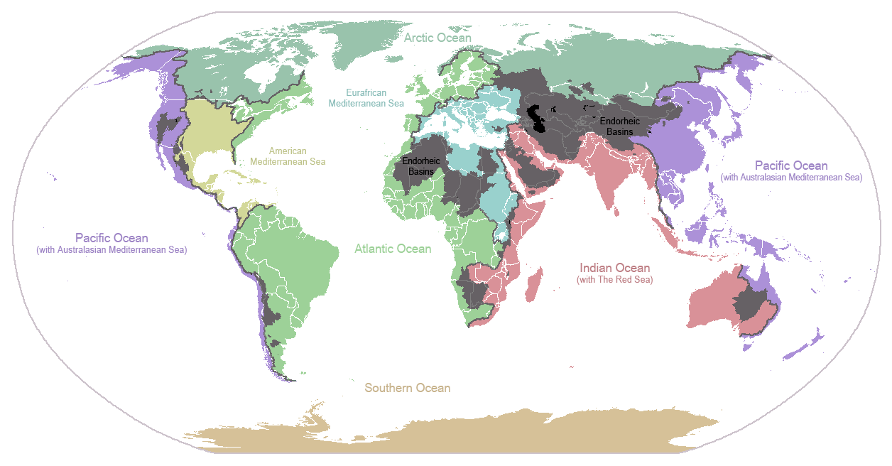
Streams can empty out into a bog or swamp, too…to say nothing of lakes and endorheic basins. That last sounds truly awful, but that’s any inland basin with no outlet to the ocean. Probably the most famous example of such a thing to Americans is the Great Salt lake, but there are many others in North America, and Eurasia has vast endorheic basins. The map below shows endorheic basins in dark gray (as well as divides separating flows between various oceans).
These tend to be in desert regions; with more water erosion will eventually cut a channel or lower the rims of the basins. This can often happen from outside of the basin, as streams flowing away from it slowly wear down the ridges separating the basin from the outside.
Endorheic lakes have no outflow, so what happens to the water in them? Evaporation. The lake will grow until the evaporation on the surface cancels out the water flowing into the lake. Of course, the rivers flowing into the lake don’t have a constant flow, meaning that the lake can–and does–vary in size. This can be an issue with the Great Salt Lake, which has often flooded during El Nino seasons which tend to dump a lot of rain in the Western US. But when the levels are low there is a lot of evaporite, mostly salt, left behind. This happens at many such lakes including the Dead Sea between Israel and Jordan, and there are many dry lake beds in the Basin and Range Province centered on Nevada but including parts of Utah, California, and Oregon. (Why is this area called the basin and range province? It has mountain ranges…and it’s an endorheic basin.)
I feel as if I haven’t covered this adequately, but I’m simply out of time.