A More Serious Blurb About Mountains
Of course someone took exception to my characterizing the more prominent bumps in the terrain east of Kansas as “stupid.”
Well, every once in a while I decide to go through the exercise of being as obnoxious about Colorado as Texans are about Texas.
But it is looking more and more like Boebert will be re-elected. So maybe it wasn’t all in vain. (Of course my little ramble had absolutely nothing to do with her victory, so, well yes, it was in vain.)
So let me try to be a little more serious now, though in talking about geology I am in a realm where I have almost zero formal education and therefore much more likely to end up on the wrong side of the handlebars, or out ahead of my skis.
Mountains. Where do they come from? After all if the Earth is billions of years old (and it is), and it had mountains when it started (which, really, it didn’t), it should be glass-smooth by now from erosion with all continents worn down to sea level. (I was about to say it should look like a cue ball, but a cue ball is actually rougher than the Earth, for its size.)
So clearly mountains formed after the Earth did; well afterwards in fact. And as it happens there are mountains forming right now. And all are eroding away (even the ones that are forming) as we speak.
What’s going on here?
Well, let’s start our little tour with the Appalachians.
It was pointed out last Saturday that in spite of current appearances, the Appalachians are indeed mountains, albeit very much in the geological nursing home. According to my very surface-level research, the Appalachians first formed in the Orodovician period roughly 480 million years ago, from plate collisions between the future North America and something called the Iapetus ocean. What’s left of these mountains is largely old seabeds, rumpled up and pushed into the sky over a span of millions of years, then eroded. This range was as high as today’s Alps and Rockies (and therefore not stupid). These mountains were in the middle of the old supercontinent of Pangaea. An episode of mountain building is called an “orogeny” (and I’ve sometimes seen the term used to refer to the location where it happened/is happening) and this was the “Taconic orogeny.” A later episode in the late Carboniferous/early Permian periods, covering 325-260 million years ago, is the Alleghanian orogeny. (Yes, it’s Alleghanian, not Alleghenian as one might expect. Apparently a certain geologist couldn’t spell…) Of course over hundreds of millions of years they eroded. And here is an interesting fact…the rocks that make up mountains are a bit lighter than the “mantle” rocks below our continents, so they actually, in a way, float. If you pile them up, they tend to sink into the mantle rock (which is slightly elastic thanks to its high temperature). In other words, mountains are like icebergs, most of them are below the surface. If a foot of rock erodes off the top of a mountain, the mountain will rise something like 10-11 inches to reach equilibrium, so to actually permanently shorten a mountain by a foot you have to erode ten feet off the top. But of course that only works if the mountain isn’t still being uplifted!
But what causes the uplift?
In a word…okay, two words…plate tectonics.
The entire surface of the earth is divided up into “plates.” Some of the plates are entirely ocean floor, a relatively thin layer of basaltic rock, which is heavy. Others have continental crust, a much thicker layer of lighter rock…which is why mountains are like icebergs. Most plates that have continental crust have a great deal of ocean crust too, with the continent largely if not entirely surrounded by ocean crust. If you’ve ever looked at one of those maps that shows underwater features, you’ll see around the margin of every continent, a shallow sea floor, then an abrupt drop down to deep ocean. That shallow sea floor is “continental shelf” and is geologically part of the continent even though it’s under water. The deeps are ocean floors.

The places where plates come together–the seams–are “plate boundaries” and are also fault zones. Fault zone as in “earthquake.”
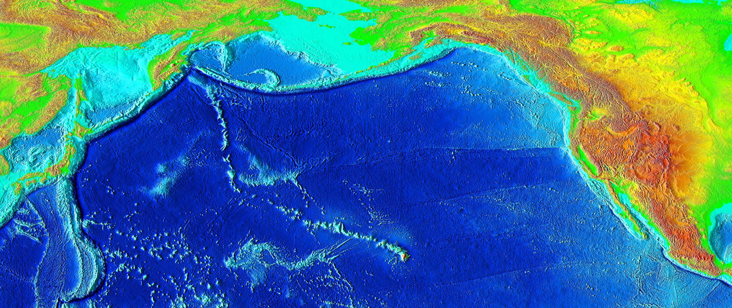
The reason mountains exist is that these tectonic plates move. The red arrows on the diagram above show the direction of motion in a number of locations.
If the plates cover all of the surface of the earth, how do they move? It’s like having one of those sliding block puzzles (arrange the numbers 1-15 in order…you know, that kind), but with no open hole to move blocks into.
Well, that’s an interesting story! And it happens, geology would make no damned sense without the answer to that question.
So let’s take a look at a few cases.
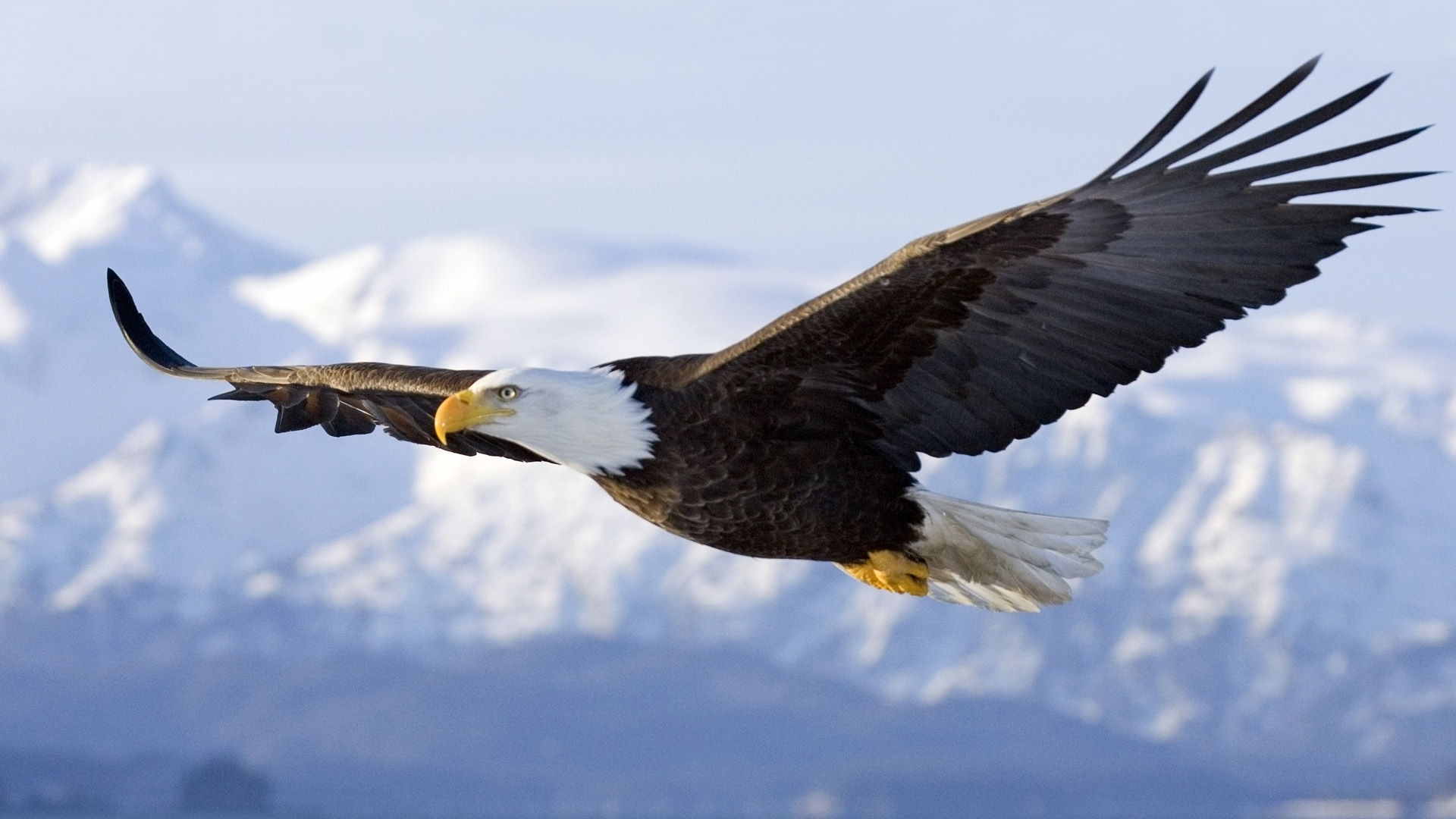
The Himalaya mountains (definitely VSG or genius level mountains) are still being built; they’re the result of the Indian plate being pushed into the Eurasian plate. In a head-on collision the continental crust has nowhere to go, so it goes up. The Himalayas are damned tall, and getting taller. Although erosion is acting on them, the uplift is faster than the erosion, resulting in a net increase in height.
Moving on to the Andes, a similar thing is going on, except that they aren’t the result of two continental plates making a head on collision, but rather of an ocean plate being pushed under a continental plate, down into the mantle. This results in a chain of volcanoes as the light sediment on the subducted ocean crust melts and forces its way to the surface as magma (molten rock)–again, its crustal rock and is lighter than the mantle, and is what’s going on under Japan and Alaska (and Indonesia and Kamchatka and the Pacific Northwest).
That’s how the plates can move. An ocean plate will be pushed under a continental plate, down into the Earth’s mantle, this is called “subduction.”
These are two of the three major ways mountains form. The third is a little less prominent…unless you look under the oceans. When you do that, you discover the longest mountain range on Earth. The main part of this is the Mid Atlantic Ridge, and it is a place where ocean floor plates move away from each other. Basically, magma wells up along a long rift in the ocean floor, and solidifies, some of it becomes part of the ocean crust attached to North and South America, and some becomes attached to Europe and Africa. It’s a bit like a conveyor belt, moving the Americas away from the Old World.
Iceland is actually on this ridge and represents a place where more than the usual amount of magma comes up through the rift (we’ll come back to that later). Reykjavik is actually on the part of Iceland that is, geologically, part of North America, while the eastern two thirds or so of the island is geologically part of Europe. The rift runs right through Thingvellir park (Icelandic spelling: Þingvellir), near where the original Icelandic Althing met. (The Althing is the Icelandic parliament, and it has been a going concern since 930. That is not a typo; it’s the oldest parliamentary body in the world.)
Once, North America and Europe were joined, and South America and Africa were joined. But then for some reason, deep inside the earth, the continents were slowly, inexorably tugged apart. A rift began to form; the land inside that rift simply began to sink (it wasn’t a gigantic crack through all that rock), until it dropped below sea level, then a shallow sea was there and as the continents moved further apart, finally a deep ocean, the Atlantic, formed, with the Mid Atlantic ridge where the rift originally was. And the continents are still moving apart. (We can actually measure this in real time thanks to GPS and lasers–they move apart about as fast as your fingernails grow.)
Right now, Africa has a new “rift valley” running a bit east of center down the continent, starting with the Red Sea then coming ashore at Djibouti (which is measurably sinking), down through the “Rift Valley” and through all those big (and deep!) lakes, Victoria, Malawi, Tanganyika…The continent is literally splitting apart. Lake Baikal in Siberia is another example of a rift feature.

The Pacific Ocean is one large plate, with smaller plates around the edges, almost none of it continental crust. But one exception we’re all aware of is Baja California and part of the US state of California. As the Atlantic spreads, the Pacific must shrink and the continents are moving into the Pacific. The Pacific ocean floor is getting pushed under the continents around its margin, which is where the “Ring of Fire” comes from.
As I said the Pacific isn’t just one big plate, and there are more mid-ocean ridges in the Pacific. But their net effect is to simply produce ocean crust that’s going to get pushed under North and South America and Asia even faster, because that crust is moving towards the continents, head on. There are two ridges in the eastern Pacific (i.e., the parts nearest the Americas), the Juan de Fuca near the Pacific Northwest, and the East Pacific Rise, a couple of thousand miles off the coast of South America. The plates to the east of the East Pacific rise are the Cocos and Nazca plates, and the Nazca plate subduction under South America is what is pushing the Andes up.
In fact, plate tectonics explains almost all volcanos and mountain ranges on Earth, and it might interest you to know that we did not understand plate tectonics in 1960. As a kid I had a book about volcanoes, and it was maybe twelve years old and totally out of date. It said, in essence, that we didn’t know why volcanoes showed up where they did and not other places. The entire science of geology went through a revolution during that decade. I’ve seen videos of college professors who were students during that time, describing what it was like to be getting into the field during such a time–it was exciting! (And perhaps I can tell that story, sometime.) It represented the final vindication of Alfred Wegener.
Alfred Wegener (1880-1930) is famous for suggesting that the continents move. It explained a lot of things, such as matching rock formations and fossils on either side of the Atlantic, to say nothing of how the outlines almost look like puzzle pieces, especially if you look at the edges of the continental shelves.
But the problem was, no one could see how the continents could just plow through the ocean crust. Wegener was considered a crackpot. The correct answer–that the ocean floor isn’t something continents have to plow through, it’s a conveyor belt carrying the continents with it–finally became clear during the 1950s and 1960s, long after Wegener had died.
These edge-of-tectonic-plate effects account for almost all volcanoes and mountain ranges…which means not all of them. A couple of prominent exceptions are Hawaii, and the Rocky Mountains. But even there, plate tectonics helps explain them.
We can start by taking a look at the Pacific Plate (and adjoining plates).

You’ll notice in the upper right the Juan de Fuca plate (and ridge), and at the mid-right edge the Nazca and Cocos plates. Easter Island, it turns out, owes its existence to these tectonic forces, as do the Galapagos islands (unlabeled, but a couple of hundred miles south of the junction of the Nazca, Cocos and Pacific plates).
Hawaii is smack dab in the middle of the upper part of the plate (it’s shown in very low contrast outline), and the forces that create volcanoes and mountains generally operate at the edges of plates. Hawaii is thousands of miles from such an edge. So how is it that the Big Island–which is a humongous multi-peaked volcano, which if measured from the ocean floor on which it rests, is taller than Mount Everest (thus, distinctly unstupid) is way the heck out there?
Well, there’s another feature of geology, somewhat related to mid ocean ridges, known as hot spots.
There is, apparently, a “hot spot” deep underground in the interior of the Earth, that has been pushing magma upwards for tens of millions of years. The Pacific plate is moving northwest over this hot spot. The Big Island is over it now, but in the past, Maui and Oahu were. They’re no longer active volcanos and have been eroding away ever since which is why the Hawaiian islands get smaller the further away they are from the Big Island. In fact, the island chain continues clear out to Wake Island. Beyond Wake Island, there’s a long line of undersea mounts…former islands running off to the west-northwest of Hawaii…then suddenly, as you follow it further west and further into the past, it turns north. The Pacific plate was once moving northward, then abruptly turned west, and you can follow the line of travel over the hot spot by following those undersea mounts–which are now called the Emperor Seamounts
So yes, plate tectonics doesn’t tell you why Hawaii is there…but it does explain why there’s a long string of islands and former islands there, rather than just one really, really big volcano in the middle of the Pacific Ocean. (Imagine what it would look like if ALL of that vulcanism happened at the same spot on the Pacific Ocean floor, rather than along a line.)
That diagram shows you the other conundrum–the Rockies, too, are nowhere near a plate boundary. You can see the Colorado Rockies, halfway down near the right side, and distinctly reddish from their altitude. The San Andreas in California is the plate boundary, and it’s actually two plates sliding sideways past each other, rather than away from each other or into each other, which makes for not much mountainbuilding and actually, milder earthquakes. (California quakes are nothing next to things like the Chilean, Alaskan and Japanese earthquakes along subduction zones; the two worst earthquakes reliably measured were in Alaska and Chile in the 1960s; the Fukushima-wrecking quake wasn’t that far behind.)
The Pacific plate actually touches a continent in two places, Alaska and California. There’s no mid ocean ridge off the coast of California.
But with a little imagination, you can see that perhaps once upon a time the East Pacific rise and the Juan de Fuca ridge were connected…but the connection has been overrun by North America as it moves west away from the Mid Atlantic ridge!
In fact, geologists strongly suspect this is what’s going on, and they call the old, combined but now subducted plate the Farallon plate. An actual mid-ocean ridge ended up under North America, and it’s perhaps only a couple of hundred miles under North America, and still spewing magma down there. And that is what pushed up the Rockies. Give it long enough, and it might just put mountains in Kansas, because Kansas will eventually be over that old, buried midocean ridge. (However, the bit about the ridge still operating down there is a bit speculative; most geologists seem to think it’s all due to the old Farallon plate being at a fairly shallow depth and friction causing the uplift.)
The Rockies, by the way, are estimated to have once been 25,000 feet tall, with a large Tibet-like plateau at 20,000 feet, but they stopped being pushed up roughly 55 million years ago (that was the “Laramide Orogeny”) and have been eroding ever since. Ten thousand feet in 50 million years.
One last thing. Is that Hawaiian hot spot particularly unusual? Yes and no. There are plenty of hot spots, but they tend to be on mid ocean ridges and rift zones, in fact they probably help continents break up and form those ridges and rifts in the first place. Iceland is an example, but there are other mid-Atlantic islands like the Azores, St. Helena, Tristan da Cunha and so on that are likely hot spots albeit not as strong as Hawaii–those are all on the Mid Atlantic ridge. Hawaii is unusual in being nowhere near a ridge.
But there’s another hot spot nowhere near a ridge or rift valley, and that’s Yellowstone. And there’s a key difference between it and Hawaii–it’s under a continent. When Hawaii erupts, it erupts, basically, molten basalt and that tends to be a gentle eruption. The hot spot under Yellowstone, by contrast, heats up granitic rock. Molten granite is much thicker, gooier stuff and will erupt explosively…which is why when Yellowstone goes, it’s a Big Deal, an absolute catastrophe for the world. When it goes, it doesn’t just destroy a mountain…it takes a huge chunk out of a mountain range. And it will probably trigger an ice age all by itself, after dumping several feet of ash over something like a million square miles. (Honestly, I want to be on Mars when this thing goes kablooey!)
Remember that terrain map of Colorado I showed you last week? Here’s the one for Idaho from the same site (geology.com). (All of my maps from last week besides the congressional district one were from geology.com.)
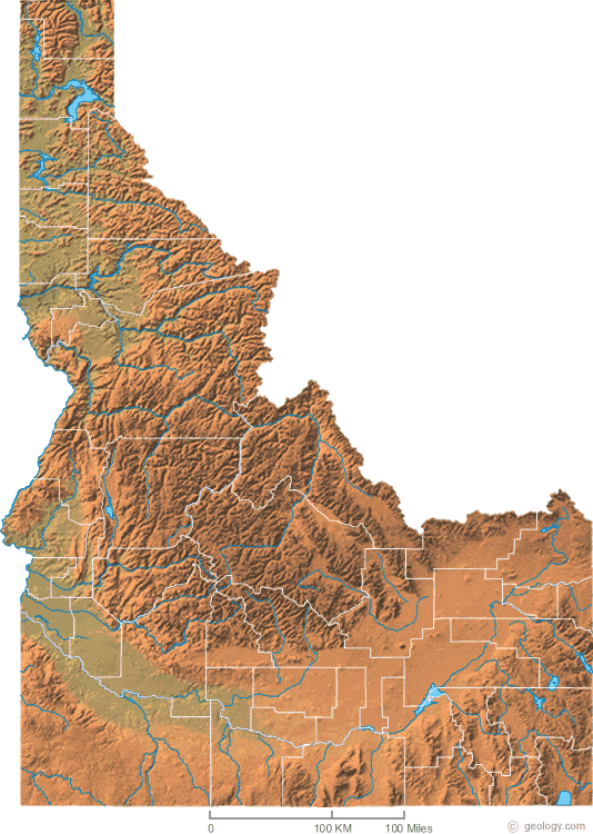
Note the big, flat floored valley running in an arc across the southern part of the state. And also note that instead of the mountains framing that valley as was the case for Colorado’s San Luis Valley, the valley looks like it was bulldozed across or perpendicular to the riges. And then, remember what’s off that northeast corner…Yellowstone. Meet the bulldozer.
That valley was literally blasted out of those mountains, by Yellowstone. North America is moving west-southwest over the hot spot, and every time Yellowstone blows, a bit more of that broad valley is formed, it gets cut deeper and deeper into the Rocky Mountains.
Now here’s the thing I realized (and if I can realize it as I go further and further over the edge of my skis, then actual geologists have probably thought of it and either laughed because they know some reason (that I don’t) that makes it ridiculous, or they’ve actually thought about it for at least five seconds.
I mentioned hot spots tend to be found around ocean ridges (and also rift valleys, which are how continents split and form those ridges to begin with). And that in large part really, it’s the hot spots that cause the ridges not the other way around (so of course there’s an association). I’ve also mentioned the crazy thought that the Farallon plate and its border ridge is under North America, still acting like a ridge even though it’s buried, and pushing up mountains.
What if Yellowstone was actually, many millions of years ago, a hot spot on that rift?
Anyhow, this was probably more than you wanted to know about mountains, genius level down to stupid, and even a bit about the short-tempered ones that blow their stacks.
I just hope I didn’t mangle the geology too badly.
The Real Fascist is His Fraudulency Joe Biden*
*Or whoever has his hand rammed up that meat puppet’s ass.
Brandon (which I will use as a term for whoever is the power behind the Porcelain Throne) has thrown down the gauntlet…but in a way where most of America will never see it. The networks didn’t carry his tirade. CNN air brushed it (or whatever you call editing the red background) for its five viewers (who aren’t trapped in airports).
Luckily for me I live in Colorado, and therefore, despite my best efforts, I probably didn’t vote for Donald Trump.
Of course, for this purpose who I actually did try to vote for will be essential, and they undoubtedly know.
Come and get us, asswipes!
Justice Must Be Done.
The prior election must be acknowledged as fraudulent, and steps must be taken to prosecute the fraudsters and restore integrity to the system.
Nothing else matters at this point. Talking about trying again in 2022 or 2024 is hopeless otherwise. Which is not to say one must never talk about this, but rather that one must account for this in ones planning; if fixing the fraud is not part of the plan, you have no plan.
Small Government?
Many times conservatives (real and fake) speak of “small government” being the goal.
This sounds good, and mostly is good, but it misses the essential point. The important thing here isn’t the size, but rather the purpose, of government. We could have a cheap, small tyranny. After all our government spends most of its revenue on payments to individuals and foreign aid, neither of which is part of the tyrannical apparatus trying to keep us locked down and censored. What parts of the government would be necessary for a tyranny? It’d be a lot smaller than what we have now. We could shrink the government and nevertheless find it more tyrannical than it is today.
No, what we want is a limited government, limited not in size, but rather in scope. Limited, that is, in what it’s allowed to do. Under current circumstances, such a government would also be much smaller, but that’s a side effect. If we were in a World War II sort of war, an existential fight against nasty dictatorships on the brink of world conquest, that would be very expensive and would require a gargantuan government, but that would be what the government should be doing. That would be a large, but still limited government, since it’d be working to protect our rights.
World War II would have been the wrong time to squawk about “small government,” but it wasn’t (and never is) a bad time to demand limited government. Today would be a better time to ask for a small government–at least the job it should be doing is small today–but it misses the essential point; we want government to not do certain things. Many of those things we don’t want it doing are expensive but many of them are quite eminently doable by a smaller government than the one we have today. Small, but still exceeding proper limits.
So be careful what you ask for. You might get it and find you asked for the wrong thing.
Political Science In Summation
It’s really just a matter of people who can’t be happy unless they control others…versus those who want to be left alone. The oldest conflict within mankind. Government is necessary, but government attracts the assholes (a highly technical term for the control freaks).
A Few Things We Cannot Blame on His Fraudulency
I am pretty sure Joe Biden had nothing whatsoever to do with the 30 Years War that ran from 1618-1648 and probably killed about a third of the people then living in what is now Germany.
Nor did he cause the collapse of either Roman empire (Western, 476 CE, Eastern 1453 CE). Nor the ignominious failure of most of the Crusades. Nor the collapse of Bronze Age civilization around 1200 BCE (including the collapse of the Minoans and the blowup of Santorini).
However, my utter lack of ability to imagine how he could possibly be responsible for these things is not a valid argument against them, so I await correction if appropriate.
His Truth?
Again we saw an instance of “It might be true for Billy, but it’s not true for Bob” logic this week.
I hear this often, and it’s usually harmless. As when it’s describing differing circumstances, not different facts. “Housing is unaffordable” can be true for one person, but not for another who makes ten times as much.
But sometimes the speaker means it literally. Something like 2+2=4 is asserted to be true for Billy but not for Bob. (And when it’s literal, it’s usually Bob saying it.) And in that sense, it’s nonsense, dangerous nonsense. There is ONE reality, and it exists independent of our desires and our perceptions. It would go on existing if we weren’t here. We exist in it. It does not exist in our heads. It’s not a personal construct, and it isn’t a social construct. If there were no society, reality would continue to be what it is, it wouldn’t vanish…which it would have to do, if it were a social construct.
Now what can change from person to person is the perception of reality. We see that all the time. And people will, of course, act on those perceptions. They will vote for Trump (or try to) if their perception is close to mine, and vote against Trump (and certainly succeed at doing so) if their perception is distant from mine (and therefore, if I do say so, wrong). I have heard people say “perception is reality” and usually, that’s what they’re trying to say–your perception of reality is, as far as you know, an accurate representation of reality, or you’d change it.
But I really wish they’d say it differently. And sometimes, to get back to Billy and Bob, the person who says they have different truths is really saying they have different perceptions of reality–different worldviews. I can’t argue with the latter. But I sure wish they’d say it better. That way I’d know that someone who blabbers about two different truths is delusional and not worth my time, at least not until he passes kindergarten-level metaphysics on his umpteenth attempt.
Lawyer Appeasement Section
OK now for the fine print.
This is the WQTH Daily Thread. You know the drill. There’s no Poltical correctness, but civility is a requirement. There are Important Guidelines, here, with an addendum on 20191110.
We have a new board – called The U Tree – where people can take each other to the woodshed without fear of censorship or moderation.
And remember Wheatie’s Rules:
1. No food fights
2. No running with scissors.
3. If you bring snacks, bring enough for everyone.
4. Zeroth rule of gun safety: Don’t let the government get your guns.
5. Rule one of gun safety: The gun is always loaded.
5a. If you actually want the gun to be loaded, like because you’re checking out a bump in the night, then it’s empty.
6. Rule two of gun safety: Never point the gun at anything you’re not willing to destroy.
7. Rule three: Keep your finger off the trigger until ready to fire.
8. Rule the fourth: Be sure of your target and what is behind it.
(Hmm a few extras seem to have crept in.)
(Paper) Spot Prices
Last week:
Gold $1,772.30
Silver $21.80
Platinum $1037.00
Palladium $2,132.00
Rhodium $14,450.00
This week, 3PM Mountain Time, markets have closed for the weekend.
Gold $1,752.20
Silver $21.05
Platinum $988.00
Palladium $2,020.00
Rhodium $14,150.00
Everything is down for the week, a bit, unsurprising given the huge jump last week.
Obligatory PSAs and Reminders
China is Lower than Whale Shit
Remember Hong Kong!!!
中国是个混蛋 !!!
Zhōngguò shì gè hùndàn !!!
China is asshoe !!!
China is in the White House
Since Wednesday, January 20 at Noon EST, the bought-and-paid for His Fraudulency Joseph Biden has been in the White House. It’s as good as having China in the Oval Office.
Joe Biden is Asshoe
China is in the White House, because Joe Biden is in the White House, and Joe Biden is identically equal to China. China is Asshoe. Therefore, Joe Biden is Asshoe.
But of course the much more important thing to realize:
Joe Biden Didn’t Win
乔*拜登没赢 !!!
Qiáo Bài dēng méi yíng !!!
Joe Biden didn’t win !!!