Updated 11:00PM, August 31, 2019
As of 8:00am, August 31, 2019, Hurricane Dorian remains Category 4 Hurricane with sustained wind at 145mph. The storm pressure has fallen to 944 millibars, indicating strengthening. We’re only a few miles short of Cat 5. Mandatory evacuations have already been issued for portions of Brevard County. No solid storm track has been locked in, we still don’t know where this storm will land.
The Orlando Airport will close at 2:00AM on Monday morning (Sunday night).
Personal thank you to all who have contributed hints, tips, photos, maps, this has definitely turned into a group effort. Where we go one, we go all. Thank you for your generosity. Please pardon me if I have forgotten to name you specifically, working quickly here. Issuing apology in advance.
Here is the 11:00PM Bulletin from NOAA.
000 WTNT35 KNHC 310240 TCPAT5 BULLETIN Hurricane Dorian Advisory Number 27 NWS National Hurricane Center Miami FL AL052019 1100 PM EDT Fri Aug 30 2019 …DORIAN EVEN STRONGER… …NOW PACKING 140 MPH WINDS… SUMMARY OF 1100 PM EDT…0300 UTC…INFORMATION ———————————————– LOCATION…25.5N 71.4W ABOUT 545 MI…880 KM E OF WEST PALM BEACH FLORIDA ABOUT 375 MI…605 KM E OF THE NORTHWESTERN BAHAMAS MAXIMUM SUSTAINED WINDS…140 MPH…220 KM/H PRESENT MOVEMENT…WNW OR 300 DEGREES AT 10 MPH…17 KM/H MINIMUM CENTRAL PRESSURE…948 MB…28.00 INCHES WATCHES AND WARNINGS ——————– CHANGES WITH THIS ADVISORY: None SUMMARY OF WATCHES AND WARNINGS IN EFFECT:A Hurricane Warning is in effect for… * Northwestern Bahamas excluding Andros Island A Hurricane Watch is in effect for… * Andros Island A Hurricane Warning means that hurricane conditions are expected somewhere within the warning area. A warning is typically issued 36 hours before the anticipated first occurrence of tropical-storm- force winds, conditions that make outside preparations difficult or dangerous. Preparations to protect life and property should be rushed to completion. A Hurricane Watch means that hurricane conditions are possible within the watch area. A watch is typically issued 48 hours before the anticipated first occurrence of tropical-storm-force winds, conditions that make outside preparations difficult or dangerous. Interests in southern and central Florida should monitor the progress of Dorian. For storm information specific to your area, please monitor products issued by your national meteorological service.
DISCUSSION AND OUTLOOK ———————- At 1100 PM EDT (0300 UTC), the center of Hurricane Dorian was located near latitude 25.5 North, longitude 71.4 West. Dorian is moving toward the west-northwest near 10 mph (17 km/h). A slower west-northwestward to westward motion should begin tonight and continue into early next week. On this track, the core of Dorian should move over the Atlantic well north of the southeastern and central Bahamas tonight and tomorrow, be near or over the northwestern Bahamas on Sunday, and be near the Florida east coast late Monday.
Data from a NOAA Hurricane Hunter aircraft indicate that the maximum sustained winds have increased to near 140 mph (220 km/h) with higher gusts. Dorian is a category 4 hurricane on the Saffir-Simpson Hurricane Wind Scale. Some additional strengthening is possible tonight and Saturday. Although fluctuations in intensity are possible early next week, Dorian is expected to remain a powerful hurricane during the next few days. Hurricane-force winds extend outward up to 30 miles (45 km) from the center and tropical-storm-force winds extend outward up to 105 miles (165 km). The latest minimum central pressure based on data from a NOAA reconnaissance aircraft is 948 mb (28.00 inches). HAZARDS AFFECTING LAND ———————- WIND: Hurricane conditions are expected in the hurricane warning area in the northwestern Bahamas by Sunday, with tropical storm winds beginning Saturday night. STORM SURGE: A life-threatening storm surge will raise water levels by as much as 10 to 15 feet above normal tide levels in areas of onshore winds in the northwestern Bahamas. Near the coast,the surge will be accompanied by large and destructive waves. RAINFALL: Dorian is expected to produce the following rainfall accumulations this weekend into the middle of next week: Northwestern Bahamas…10 to 15 inches, isolated 20 inches. Coastal sections of the southeast United States…6 to 12 inches, isolated 18 inches. Central Bahamas…2 to 4 inches, isolated 6 inches. This rainfall may cause life-threatening flash floods. SURF: Swells are likely to begin affecting the east-facing shores of the Bahamas, the Florida east coast, and the southeastern United States coast during the next few days. These swells are likely to cause life-threatening surf and rip current conditions. Please consult products from your local weather office. NEXT ADVISORY ————- Next intermediate advisory at 200 AM EDT. Next complete advisory at 500 AM EDT.
NOAA at about 10:45pm on August 30th.
From Smiley2
Smiley provided us a live link to the Bahamas. Excellent.
BREAKING : Hurricane WATCH ~ NW BAHAMAS …
**BREAKING** Hurricane Watches have been issued for the NW Bahamas. That means hurricane conditions are possible
within the watch area, and it’s issued 48 hours before the anticipated first occurrence of tropical-storm-force winds. We are LIVE with the latest #tropics #Dorian pic.twitter.com/dl8ICIrrPR
— WeatherNation (@WeatherNation) August 30, 2019
I strongly recommend the latest video from Tropical Tidbits that explains the hurricane prediction. In short, the hurricane slows to a crawl over the weekend, which MAY provide enough time to allow other troughs to come in and move the hurricane away from shore. Unfortunately, stalling out over the Bahamas for days creates Harvey-like flood, wind, storm surge problems for the Florida coast (not to mention the people in the Bahamas are screwed).
From SadieSlays — my ghostwriter for the duration of Dorian.
[youtube=https://www.youtube.com/watch?v=ZsBHlzkwHz0&w=640&h=360]
Intense thunderstorm towers close to the EYE of the Hurricane.
Florida Emergency Management, informative website and bulletins out of Florida: https://floridadisaster.org/
Almost everyone who lives in the southeast has a family “plan” for hurricanes. When I grew up in New Orleans, had grandparents in Pensacola, and lived in Miami, the “plan” was for me to travel and get out of the way. Checklists were taped to an inside closet door. Even now that we are 350miles inland, we still have a list of friends/family whom we KNOW will travel to our house should a hurricane head their way. An exceptionally good Hurricane checklist can be found HERE: https://www.surfandsunshine.com/how-to-prepare-for-a-hurricane-with-hurricane-preparedness-checklist/
We can add things like: Make sure you do ALL your laundry NOW and refill all medications. A well stocked, expanded, home first aid kit. An extra set of blades for a chainsaw is a Godsend. Bleach and clean all the tubs in your home and fill with water before the storm hits (if you’re staying). Right now, bake – cookies, brownies, granola bars for a healthy boost…… and share with your local fireman/police. Right now, FREEZE extra water in big containers using milk jugs/2 liter bottles, etc., to make big blocks of ice. Extra propane for the grill and a big pot to boil water.
Best personal hint: We took about 100 dish clothes/wash clothes and wet them with fresh water, added a few drops of bleach, sealed them in Glad Bags and put them in the freezer. In the aftermath, we used those towels everywhere.
Many Florida residents are new to the state and we strongly encourage they prepare and/or rely on neighbors who are a little more experienced with hurricane preparations. KNOW your neighbors, you won’t get through the aftermath of a hurricane without help from a few friendly souls.
Please feel free to add tips, tricks, memes, hints, prayers related to Hurricane Dorian. Thank you for your help.
The President is at Camp David, Pence will travel to Poland. The President will return for a press conference at FEMA on Sunday, about 12:30pm
Nature, in all it’s power and fury is still beautiful. Look at the light show from the International Space Station.


Thanks Daughn…………………… you truly do work 24/7
Appreciate the 11:00 update and all the tips………….
Like you and your family, my home further inland here in S Carolina has provided shelter for many a relative in Charleston and up the coast.
May have to do so this week-end.
Prayers for all in harm’s way…………. prepare and stay safe. God Bless.
I hope everyone really plans this time throughout the state, and cooperates afterwards. And there are teams ready, for people and animals alike.
Good luck, stay safe everyone.
If you’re in the path, you’re probably doing what you can to secure your HOME……please remember to take a moment to secure your YARD. Everything unsecured in your yard may become a projectile and threaten your home or your neighbors. A 3x hurricane veteran noted that lawn furniture, birdbaths, smokers, and BBQs at the bottom of your pool are unlikely to be problems — and it’ll be a heckuva lot easier to fish ’em out and clean ’em than to deal with them driven by the hurricane through your windows at 90 mph.
remove all coconuts from all yard trees
= flying projectiles !
That makes sense smiley2 …. projectiles can cause harm.
I hope you will be high and dry … take care
God bless
thanks kiddo…learned the hard way ab those flying coconuts !
awwww .. you didn’t get hurt did you?! I hope not. Those coconut’s are big to be flying through the air … wow .. 🤗
no…thankfully, flying coconuts did not hit me….but slammed into the side of the house (Wilma) repeatedly…like a firing squad out there + the h’canes always sound like screaming horses being tortured on a gigantic locomotive.
just awful sound fx.
rat-a-tat-tat w/ the frikkin coconuts.
… wow … glad you didn’t get hurt but man the noise … I can’t imagine but it sound really scary …. 😐😞
… any damage to your house?
From storm chaser Reed Timmer:
.
Reed is an Oklahoma boy who started out chasing tornadoes here.
He’s made it to the bigtime now, working for AccuWeather and chasing storms all over the country.
Pres Trump tweeted out one of Reed’s videos of the flooding from Hurricane Flo last year.
notice that intense, eerie peachy glow …almost a neon hue….a common sight before hurricanes…everything takes on a deep peachy hue.
That’s just peachy.
Impeachable Cad !
😀 <3
Time lapse footage shows Dorian strengthening and the formation of a eyewall:
THREAD – click any tweet
https://twitter.com/TheBadDadder/status/1039943860120694785
https://twitter.com/TheBadDadder/status/1039976064536260609
…can’t help but wonder.
I keep an open mind about OUR acquiring such science, but I tend to believe it – like many other things – was discovered elsewhere long ago. Carbon has been working the same way for a very long time.
Wonder if “Ziggy’s” little girl, MIKA, has knowledge of HAARP that the rest of us don’t.
Mika lives now in Florida she can thank daddy 🙂
Elizabeth !
Good to see you here…………………….
hope you are well. Have been missing you and your posts !
latest GFS …


latest Global …
latest Intensity Guide …
Dorian is now a Cat 4 ….
a lot has changed since yesterday !
hugging the east coast more…which, interestingly, was a very early prediction…seems that ridge of HIGH pressure in the Atlantic must be lifting, allowing Dorian to move north and east, more so than yesterday’s models.
…and this will probably keep changing, as the thing approaches so s-l-o-w-ly…criminy.
Waiting on a hurricane…. some of the best poker games I’ve ever been involved in….
LOL girl ! 😀
Slowly….
You know what’s weird, we had some thunderstorm super cells pop up yesterday afternoon. This was predicted. We knew it was coming, but usually, they get a head wind and zip through. Not last night. The storm(s) was moving amazingly slowly. One of the local guys commented on it once the hooks were gone off the radar. Because of that, some spots were getting 2-4 inches of rain in half an hour.
And now this hurricane is moving slowly. Coincidence, I’m sure, but still weird.
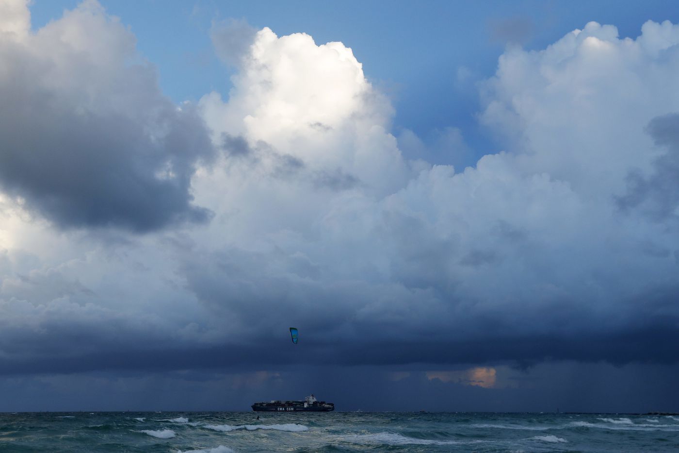
right now (10:30 am Saturday), we are getting tiny wind gusts, and the white cumulus pretty clouds overhead in the bright blue sunny sky are literally racing by at a rapid clip….it’s def out there…
and we will def feel something…
what’s interesting this time is that the 3rd in place model of the top 3 (GFS,EURO and CMC)…the CMC model….has been consistently showing this northeastward trend from the gitgo…
next time, I, for one, will pay more respect to the CMC…but of course let’s hope there is no next time this season, shall we !
SWFL <3
Looks like at some point, Newfoundland, that wild and scenic place, will be pounded by Dorian.
I had a long vacation there many years ago. Still have some photos of that time and will never forget it. The McDonald’s in Corner Brook served a lobster version of the Big Mac!
amazing how quickly these things can change.
nothing is outside the realm of possibilities.
a lot of good local info in this article out of Orlando…..
Hurricane Dorian Strengthens Into Cat 4 As It Inches Toward Florida
https://www.orlandosentinel.com/weather/hurricane/os-ne-hurricane-dorian-florida-path-20190830-g6c3gsf4uvcmlkm5dbfrvazefm-story.html
(from 11 pm last night)
it is crawling at 10 mph..
375 miles east of NW Bahamas..
545 miles east of West Palm Beach..
as of 11 pm, sustained winds of 145 mph …
Hurricane force winds extending 30 miles from center …
TS storm winds at 105 miles from center.
Orlando Int’l Airport will cease all commercial operations at 2 am Monday …passengers need to check w/ their respective airlines for more info & schedules…
the following Counties will close all schools on Tuesday :
Brevard, Lake, Orange, Osceola, Seminole, and Volusia..
UCF has cancelled Friday (yesterday) and Tuesday classes…ditto Rollins College…
40 % of Florida’s gas stations are without fuel …
Gov De Santis: state is waiving weight restrictions, giving fuel tankers a police escort to resupply the stations.
SunRail has suspended all service, all week…
much more info…plus various hot lines to call (incl for price gouging !)…and other relevant links embedded in the article…
Orange Co.Mayor Jerry Demings : It’s showtime….we’re ready.
Day of the Cat
=^-^=
Thank heaven it’s a relatively tight storm, not big and wide. Less people at risk.
not another IRMA …everybody still has major jitters from that one….
hoping this won’t be anything like Andrew either !
amazing how it keeps changing.
hope the wretched thing just goes out to sea.
adios…forever.
George was that way for us. I could stand at the end of the block and wave down the street at George – it was so small.
But I’ll never forget the moment I first saw the satellite image of Katrina, 1200 miles wide. It filled up the whole Gulf.
Big T and I were dating. I was on the phone with him when the image came up on screen….. my blood ran cold. I knew. That was the one Daddy warned us about.
…and one you’ll never forget (Katrina)…made history, that one.
The day Katrina hit, it was a beautiful sunny day here until about 4:30-5:00, and then we got angry gray clouds and a fine mist, which is weird for us at that time of the year. Looked at the satellite pictures, and sure enough, Katrina was big enough to stretch 500 miles north of landfall.
We had some damage here from Katrina, shingles, and the 5 finger groove dentil moldings. Amazing, considering we sit 350 miles away from coast. Our house is tall though, and probably why we caught gust.
The levee which broke though, by the lakefront 17th Causeway, I crossed everyday on my way to school.
Hurricane Rita, coming in right afterwards, and Hurricane Cindy (before in July of that year), was what annihilated New Orleans and the MS Coast.
There were so many threats in those years, ’72-2000, we became used to the prepare and then nothing mindset.
yes…the water shelves are depleted…yes there are greedy Big Fat Fatties who grab more than their fair share…


but…there are still plenty of healthy alternatives !
such as…juices ! 😀
all kinds…with sugar if that’s your thing….
or, better, without…or less of it…
shelves are still well-stocked !
🙂
and….
we got this!
Day of the Cat
=^-^=
Save the reptiles in Florida!
There’s still time to go outside and gather up all the alligators and large snakes you can, then bring them home with you so they stay safe during this hurricane.
Save the gators!
😉
will you plse share whatever you’re smoking 🙂
Sorry, but all wildlife is on its own.
NEW CONE!
Thanks Sadie, updating now.
Savannah and Charleston. Again.
Please, Lord – Sharp turn to the right and out to sea – in the name of Jesus – we pray – Amen
keep laffing
it helps
🙂
Mark Dice has a good laugh or two
https://www.youtube.com/watch?v=1s-MQ-HZbwM
lol andy hahahah 😀
satellite…
See that front that went through Oklahoma?
That’s a cool front.
We’re hoping that it punches all the way down to Florida and pushes Dorian out a bit.
🤞😏🤞
There’s a warm front as well. It’s supposed to pass over us today.
HEADS UP SOUTH CAROLINA …latest possible scenario as this thing continues to tease us…
and notice (above posts) how the Intensity Guide has also changed…dramatically !
get that thang !
Cat says scat !
=^-^=
Stay Safe Everyone.
=^-^=
Day of the Cat
😀
as of this morning at 6:36 am…..wow…what a difference a day makes…
If you hurry, you could catch the next flight of the hurricane plane and here’s the view you’d get
whoa…inside the eye .
That pic is inside the eyewall of Dorian. Imagine the fun getting in there and coming back out.
Yeeehaw!
Hope Mar-a-Lago survives with no damage.
https://www.foxnews.com/politics/trump-says-mar-a-lago-can-handle-itself-as-resort-in-hurricanes-path
It will be fine, andy – bypassed by the grace of God – imho – as will others.
Oh, so you have a crystal ball too?
😉
No, andy – I believe in the Power of God!!! If He can part the waters of the Red Sea – He can certainly fling a hurricane ‘out to sea’!!!
I see spaghetti models being posted from Mike’s Weather Page. He provides a compilation of NOAA.gov predictions as well as other models. You can check out his FB page and here’s a link to his website https://www.spaghettimodels.com/
So I don’t know a lot about these scenarios but I’m guessing the TABS path would really suck. Hopefully it just goes back out to sea.
Looks like Charleston is under the gun to be hit by Dorian. So sad for them.
Texted my niece in Charleston, actually Isle of Palms ……………..
She texted back that they are prepared, but reminded me that too early to tell, and there’s always hype.
(We go through this every storm……….. Hugo was the last one my family went through, horrific !)
Hugo was devastating!
Born and reared there Georgia……………. it was six months before I could drive there, and even then 75 miles out in Orangeburg, the surroundings looked as though they had been carpet bombed………. pine trees in median on freeway were topped to about two feet for miles. Cried all the way.
Hurricanes are nothing to joke about or mess around in.
Every June, Dad would buy the obligatory case of tuna/shrimp (for anyone in New Orleans to eat shrimp out of a can meant true desperation) and those awful Carnation breakfast bars (remember those things?), new flashlight batteries, and stock the workshed with gallon milk jugs of water. He was a Marine – always prepared.
One storm, we lost power for a few days, can’t remember the storm. We had redone our garage into a game room and the neighborhood men decided to get together for a poker game. I couldn’t have been more than 12. Great memories.
Block ice stays longer than cube ice. For those of you who don’t have containers (me), I use ziplock bags. Fill quarts and gallon sizes with water, put in freezer, block ice tomorrow. I Also give the ice maker a workout. By frequently bagging and removing the cubes it makes, it keeps working to fill up the bin. And my most used trick. I freeze bottles of water, they’re always in my freezer. Anytime I pack an ice chest, I throw in some cubes, 2-3 frozen water bottles and rest of drinks. Stays cold all day! Once the bottles melt, you have more drinking water.
On Milk jugs – here’s a great tip.
Once frozen, drop a quarter in the top. It will settle on the surface of the ice.
Sometimes, power comes back on sporadically, and the ice will begin to melt and refreeze.
If the quarter is gone (sunk to the bottom), check the contents of the freezer carefully.
LOL..wish I had heard of this years ago. Lord love her, my mother thought nothing would go bad in her upright freezer..ever..no matter the power outages now and then.
For crossthread42 —
Hope your area is spared! Stay safe.
Thanks for the hard work and research (as always), Daughn! This is the most extensive and detailed hurricane Dorian report I have found so far! I have close family all over Florida and I am sending this out ASAP! Thanks, again!
Take care of them. We love you guys!!
Thinking of all of you, and commiserating with how hard the wait must be from ‘not knowing’ to ‘it’s here’.
Thank goodness for so many great tracking sites and advice from weather-hardened Treepers. The videos are mind-blowing. I like to check windy.com where you can touch the screen and see wind flow patterns worldwide.
May Our Lord keep you all safe during the storm 💞💞
Wow, so many of the comments on the Twitter feed on this are NASTY about POTUS — “so you’re playing golf while Dorian is getting stronger” to “maybe the hurricane coming to Mar-a-Lago is a sign from God of dissatisfaction with how the country is being run” type of cr@p.
I find it always to be the case, so I don’t look at comments anymore 😉
Could most of them be Bots ? We KNOW POTUS is at Camp David this weekend, that he is not playing golf, but monitoring the storm (and perhaps THE STORM), and Dorian is NOT headed for Mar-a-Lago
The Cabal and its minions and methods are illusion and delusion (imho) ……………. A very HIGH percentage of Americans are with our POTUS…. VERY HIGH. Algos push these Bots up to the top of the streams, mainly to depress his base. Don’t be taken in by their evil.
latest 11 am track….etc….Florida not out of the woods yet… stay cautious, vigilant,prepared…
https://www.facebook.com/mikesweatherpage/posts/10157276700992367
Weather.com report
https://weather.com/storms/hurricane/news/2019-08-31-hurricane-dorian-bahamas-florida-georgia-carolinas-forecast
BAHAMAS ! <3 Cat 5 ??
monster !
heading towards Northern Bahamas ca 2 hrs ago….
🙁
Probably some good deals on Bahama vacation resorts right now. Lots of cancellations, so here’s your chance to enjoy a wonderful weekend lying on a Bahama Island beach in your bikini sipping tropical drinks. 🙂
I wish I could laugh…but I have some good friends who have a winter vacation place there…they live in Denver…just heard from them…very stressed & sad ab this…as am I.
🙁
Surely they have hurricane insurance.
still a sickening feeling…some things can’t be replaced.
You could be a good friend and take a boat out there to wrap up their belongings so they don’t get damaged…..
😉
smiley2
still a sickening feeling…some things can’t be replaced.
______________________________________-
What helps me is when I remind myself that I am not my stuff. My spiritual destiny is different from my stuff. Many times I look at things I like and detach myself and give it away. Stuff should never own me that does not mean I do not enjoy as long as I have it but when I get to attached to it then it needs to go.
I like old things many things cannot be replaced but there is an opportunity to buy something new something different to create new memories. I have seen my mother pain over the stuff she lost in WWII and I swore never will put stuff over life and family or good health.
A friend at one time said to me when he lost all in firer “that he cannot take a UHaul to the cemetery.” That always is a good reminder.
smiley2 stay safe and your family . I be thinking of you and praying for you and all the people on this path of the Hurricane.
insurance doesn’t cover water damage……………….
and I’m not sure, but I would think most of the people who live in virtual shacks, cannot afford insurance of any kind…………….. and their very lives are at stake, forget their modest living arrangements.
Here’s a link to cache of images of damage done by Hugo to Charleston area
https://duckduckgo.com/?q=images+of+Hugo+hurricane+damage&atb=v159-1&ia=images
and here’s link with images of damage to Virgin Is and Bahamas by past hurricanes………….
https://duckduckgo.com/?q=images+of+hurricane+damage+to+Bahamas&atb=v159-1&ia=images
Glad you said that…if there’s a hurricane or flooding..assuming that your home is still standing. The cost to quickly try and repair drywall, maybe studs, roof, cabinets, hvac plus every piece of furniture usually exceeds what payout insurance allows.
I’m praying about my place at Pawleys Island. Last year we were blessed that it passed through without much damage but so many others in surrounding areas weren’t.
Hi Carolina Girl,
praying and hoping Dorian skirts FL and Eastern seaboard and moves on out to sea!
Yes on that prayer! I felt drained last year ., it was so slow moving and I was watching as many hours a day online from storm chaser vids, any local cams that I could find and the daily updates from my neighbors who are saints in my eyes. They take care of the house when I’m not there which is most of the time.
This yr my bro and SIL are there but so far they don’t have the right amount of …get ready ..that I feel they should!
If you don’t mind me asking..where are you in SC ?
Don’t mind at all…………………..
I’m in Aiken (near Augusta, the GA border)
Oh Aiken..I remember the relief of going through there on the long car trip every summer to stay at my grandmother’s in Columbia…I knew we were getting close when we went through Aiken!
I lived in Columbia for a time, a salesman who reported to me told me a corny joke… you may have heard… “I was traveling to Augusta, but got to achin’ and stopped!
So, if you don’t mind saying, where are you now?
LOL,
I’m all the way across in San Diego. I hate Ca and want to eventually live in SC but for a couple more years I’ll be stuck here. I was born and raised in the South and will always kick myself for wandering about and having my family out here in crazy world!
I understand your yearnings… esp as you’re in CA.
Hope things work out better in CA soon, and/or that you’re able to move back to God’s country! S Carolina is great, except for an occasional hurricane of course.
God Bless you and yours
current State-of-Emergencies….South Carolina just added …
https://www.facebook.com/mikesweatherpage/posts/10157276882577367
omg…Abaco Islands…bracing for a direct hit…Cat 5…aww..
Abacos Bahamas
Dear Lord, Jesus be with them 🙏
Georgia and Carolinas heads-up …
Word from the homefront (I am not there right now) is that my sister in law and nephews arrive Monday morning from the Gulf Coast of Florida. School and work have been called for at least Tuesday and Wednesday. They’re not taking any chances.
Actual photo from space of Hurricane Matthew in 2016
https://www.facebook.com/mikesweatherpage/posts/10157277078937367
can see there that the very first, early bands are about to head into Miami area…and some other related (minor) stormy guk is also sweeping thru the Straits towards The Keys..
here in SWFL, the sky to the southeast is looming up dark and menacing…and the treetops are swaying, once in a while…all related to the massive Dorian, 300+ miles away !
been gusty on and off since yesterday afternoon, actually.
thankfully, at this time, we aren’t in the path, most likely (?) won’t be…but this storm will be felt…until it starts to die down to a Cat 2…and veer north…and hopefully WAY EAST.
my thoughts, prayers right now are for the good people in The Bahamas. <3
What about the east coast of Florida, smiley – will Flep and his family be okay?
I think her crystal ball is broken, so she probably doesn’t have an answer to that question.
Be nice, andy – smiley has provided us with great information – you know
better not tell you now….try again later….
🙂
Uh, oh – andy said you had a crystal ball!
Don’t like where this is going – Newp!!!
what does “Newp” mean ?
you said it yesterday to me in a Reply, too.
An offshoot of ‘Nope’ –
andy said: “I think her crystal ball is broken, so she probably doesn’t have an answer to that question.”
Yes, indeed. I said that. 🙂
who’s on first ?
Time for a laugh !
Thanks, pr – I needed a good laugh!!!
YW Duchess !
* Smile *
Then the police come in, chasing him, saying “Urinal lotta trouble now”…
LUV your humor Cuppa………………. don’t ever stop !
in Charleston, S.C……
She must be new to pre-hurricane planning !
I have a rule, the grandkids know it ……… one NEVER allows the tank to get below 1/2 in one’s auto……….. and that’s 24/7 365/year. You NEVER know when there will be an emergency. And if you are warned there may be a bad storm, not even a hurricane, you FILL the tank. Rule #2 One always has cash on hand or in the house… when electricity goes, not everyone can take plastic. Rule #3 ALWAYS carry a flashlight, a blanket, and gal of water in the car. (There’s a reason for these rules, having lived the consequences of NOT observing these rules in younger years!)
she’s “stunned” , maybe, b/c in her “wildest dreams” she’s the center of her universe ??
see all kinds in dire situations of survival like an oncoming Cat 4 hurricane…the water aisles in the local supermarkets here past 2 days (and this is a “high end” town, they say!), for example, have been like the mean streets of Baltimore !
hands up, criminy, don’t hit me with yr shopping cart, Lard Ass !
what with elbowing in front by Big Fat Fatties trying to GRAB IT ALL, pushing, shoving, cussing, running over feet w/ shopping carts !
A swiss army knife in the console close to reach by the driver, and a small mirror in same place too.
What a ding dong.
Want to know how bad hurricane damage was after it hits? Check out which Waffle House restaurants are open.
FEMA Keeping Eye On ‘Waffle House Index’
https://www.thegatewaypundit.com/2019/08/fema-keeping-eye-on-waffle-house-index-ahead-of-hurricane-dorian-arrival/
I thought this was funny.
Didn’t Waffle House feed tons of people after Harvey? or am I mis-remembering?
I know someone did but I’m drawing a blank on who it was phoenix.
Found this………… still looking…….
https://www.houstoniamag.com/articles/2017/8/28/how-bad-is-harvey-the-waffle-houses-are-closing
NEW CONE
Brave Bahamas <3 …they will take the brunt of this and knock it down a bit…just like The Keys & Marco Island did with Irma…
🙁
Praying, smiley………….. don’t “like” ………… but appreciate the update.
There are reports online that reconnaissance flights into Hurricane Dorian aren’t as frequent as they should be because two out of the three hurricane hunter planes are out of service with cracked windshields.
“I received more information about yesterday’s recon mission. TEAL 77 had a cracked windshield. They returned to base. 307 then attempted a fix mission into Dorian, but cracked another windshield. So they aborted the fix mission and just completed the buoy drop. ”
Source:
http://www.storm2k.org/phpbb2/viewtopic.php?f=59&t=120453&sid=bd647b6ea00b9a682dff90baf1d04ffa&start=4180
Author who wrote that comment:
Posts by MikeAdcockWx
methinks “D/evil” is in the details………….. jes sayin ………… adjustin’ my very expensive tin foil hat.
Mmmhmm
I second that emotion (Mmmhmm)
Bahamas….Dorian prelude…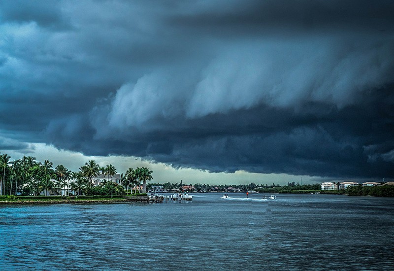

such a beautiful place.
please have some mercy, Lord.
is that a face in the storm clouds ? (Lord I’m gettin senile)
ask friend andy 😀
no wait….
Wow!
Amazingly beautiful and amazingly powerful..
where the heck can anyone evacuate TO in The Bahamas ??
not finding much ab that, either…this article has a LOT of info ab everywhere in the path of Dorian incl The Bahamas..
https://www.cbsnews.com/live-news/hurricane-dorian-update-category-4-storm-landfall-latest-track-path-models-forecast-2019-08-31/
…and Florida, and Georgia, and the Carolinas…
says they are evacuating in The Bahamas to churches, shelters and schools…
sheesh
can’t we help them get outa there ??
can’t anyone help them ??
they’re so close to mainland USA.
you know how utterly terrified they are right now.
Dorian will spin for 12 hours over Bahamas (Freeport) as a very strong Cat 4…before it finally departs.
just heard that on local News/Weather (WINK News)
12′-15′ storm surge…150 mph winds…sustained…for 12 hours.
pray that it moves just a little more NORTH to spare them !
NEW CONE – 8 PM UPDATE
You can tell the cabal’s big bad Labor Day hurricane plans are a bust since they had to pull the ol’ mass shooting card.
Guess the White Hats also know a thing or two about manipulating the weather ?
White Hat Weather Wizards™
That’s cool Georgia……………
Like the alliteration also 😉
The NHC has an animated history of the warning cones. It’s interesting to watch. As late as Wednesday, Dorian was supposed to make landfall in Florida as a Cat 3+ on Labor Day. Even the President was calling it “bigger than Andrew.” By Friday, the hurricane models had the storm slowing down to a 5 mph crawl and “waiting” for nearby air masses to carry the hurricane out to sea like we’re seeing now with the current cone. -Something- significantly slowed the hurricane down between Wednesday and Friday morning.
https://www.nhc.noaa.gov/archive/2019/DORIAN_graphics.php?product=5day_cone_with_line
Yes Sadie ..
How stupid can a person be? In power outages, how do you charge these silly electric cars?
If this woman were any dumber, she’d be a literal bag of hammers.
TWO MORE POTENTIAL STORMS!
https://www.nhc.noaa.gov/gtwo.php?basin=atlc&fdays=2
New update from the homefront…if Dorian makes the turn north by Monday morning REALLY early, we will not be getting house guests. They, meaning my sister in law, don’t want to deal with no power. God forbid she can’t be on her laptop for more hours than she is asleep on any given day.
New Tropical Tidbits video out explaining the hurricane forecasts. Strongly recommended.
Very interesting and comprehensive – Thanks, Sadie – still praying for a sharp turn out to sea – I am
Stealing for tomorrow’s post, due out in about 15 minutes
New Storm post is out if interested.
THANK YOU again to all the hints, video, pics, and stories.
You guys are the best!
We’re going to make it through this storm together.
Thanks for putting together these hurricane posts!
Sadie, we need to get together when this is over with. You’ve been terrific!
Thank you!